
How MAR Connects Water Supply, Flood Protection, and Land-Use Planning
Explains why managed aquifer recharge depends on coordinated planning across water supply, flood management, land use, stormwater systems, infrastructure, and groundwater governance.
Managed aquifer recharge is not only a groundwater project. It depends on land, infrastructure, source water, suitable soils, aquifer conditions, monitoring, and coordination across multiple public responsibilities.
This matters for water policy because MAR is most successful when water supply, flood management, land-use planning, stormwater systems, and groundwater governance are planned together rather than handled as separate decisions.
Download or reuse this guide in briefings and meeting materials.
What the visual shows
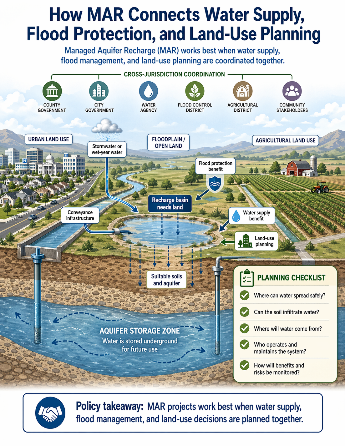
The visual shows a landscape with urban land use, agricultural land use, open land or floodplain area, a recharge basin, conveyance infrastructure, and an aquifer storage zone below the surface.
Stormwater or wet-year water is moved through canals, pipes, storm drains, or channels toward a recharge basin. The basin needs land where water can spread safely. Beneath the basin, suitable soils and aquifer conditions allow water to infiltrate and become stored groundwater.
The visual also shows several agencies and stakeholders connected through cross-jurisdiction coordination. These include city government, county government, water agencies, flood-control districts, agricultural districts, and community stakeholders.
The main point is that MAR connects many planning systems at once. A recharge project may support water supply, reduce runoff or flood stress, preserve open land, and strengthen groundwater management, but only if these decisions are coordinated.
Why MAR needs land
Recharge basins, spreading grounds, stormwater capture areas, and some infiltration systems require land.
The land must be suitable for holding and spreading water. It also needs soils and subsurface materials that allow water to infiltrate at a useful rate. If soils are too clay-rich, compacted, contaminated, or poorly connected to the aquifer, recharge may be limited.
Land-use decisions affect whether recharge areas remain available. Once open land is developed, paved, or fragmented, it may no longer be usable for recharge. Floodplain areas, agricultural lands, public lands, parks, or other open spaces may sometimes provide opportunities for recharge if geology, ownership, water quality, and operations allow it.
This means MAR should be considered early in land-use planning. Waiting until all suitable land has been developed can make future recharge projects harder, more expensive, or impossible.
How conveyance and floodwater capture fit in
Water must be moved to the recharge site. This may require canals, pipelines, storm drains, diversion structures, stream channels, pumps, gates, or other conveyance infrastructure.
In some places, floodwater and stormwater can be captured and directed to recharge basins or spreading grounds. This can reduce peak runoff or flood stress while also storing water underground for future use.
However, capturing water is not simple. Project planners need to know when water is available, whether it can legally be diverted, where it can be moved, how quickly it can infiltrate, and whether the water quality is appropriate for recharge.
Floodwater and stormwater are often episodic. They may arrive in large pulses during storms or wet periods. Recharge projects must be designed to handle this variability safely and effectively.
Why coordination matters
MAR projects often cross jurisdictional boundaries.
A city may control land use and storm drains. A county may be involved in planning or floodplain management. A water district may manage groundwater or water supply. A flood-control agency may operate channels or detention basins. Agricultural users may own land or depend on groundwater. Environmental agencies may oversee streamflow, habitat, or water quality.
Because many entities can be involved, coordination is needed for permitting, maintenance, water rights, operations, monitoring, public communication, and long-term accountability.
Without coordination, a project may face delays, unclear responsibilities, conflicting goals, or public mistrust. With coordination, MAR can be planned as shared water infrastructure that serves multiple purposes.
Policy benefits and tradeoffs
MAR can provide several policy benefits when conditions are suitable.
It can support water supply by storing water underground for future use. It can contribute to flood management by capturing some stormwater or wet-year flows. It can help maintain groundwater levels, reduce some risks associated with overdraft, and support drought resilience.
MAR can also help communities use land more strategically. Open land, floodplains, parks, agricultural areas, or public facilities may sometimes be designed to provide multiple benefits, including recharge.
But there are tradeoffs. Recharge basins require land that might otherwise be used for housing, agriculture, habitat, recreation, or other public purposes. Conveyance infrastructure costs money and requires maintenance. Stormwater and floodwater may carry sediment or pollutants. Recharge projects may affect nearby groundwater users, streams, wetlands, or infrastructure.
Policy staff should evaluate MAR as part of a broader planning system, not as a stand-alone project. The question is how the project fits into water supply, flood protection, land use, environmental protection, and long-term groundwater management.
Questions policy staff can ask
- What problem is the MAR project trying to solve?
- Is the project primarily about water supply, flood protection, stormwater management, groundwater sustainability, drought resilience, or multiple goals?
- Where is suitable land available for recharge?
- Are the soils and aquifer conditions suitable?
- Is the proposed recharge area already protected from incompatible development?
- What water source will be used?
- Is the source water available during wet periods, storm events, or flood flows?
- What conveyance infrastructure is needed to move water to the recharge site?
- Who owns, operates, and maintains that infrastructure?
- What pretreatment or sediment control is needed?
- How will water quality be monitored?
- What agencies or jurisdictions need to be involved?
- What water rights, permits, or operating agreements are required?
- How will benefits and risks be measured?
- How will the project communicate with nearby residents, landowners, water users, and other stakeholders?
- How will long-term maintenance and funding be handled?
Policy takeaway
MAR is most effective when it is planned as shared water infrastructure, not as an isolated groundwater project.
Main concept: Managed Aquifer Recharge, or MAR, works best when water supply, flood management, and land-use planning are coordinated together.
Core message: The visual explains that MAR is not only a groundwater project. It connects water supply, flood protection, land-use planning, conveyance infrastructure, suitable soils, aquifer storage, and cross-jurisdiction coordination.
Cross-jurisdiction coordination: The guide shows several groups that may need to coordinate on a MAR project.
County government: County government may be involved in planning, land use, permitting, or regional coordination.
City government: City government may be involved in urban land use, stormwater systems, infrastructure, and local planning decisions.
Water agency: A water agency may manage source water, groundwater storage, recovery, operations, or water supply.
Flood control district: A flood control district may manage stormwater, floodwater capture, channels, or flood-risk reduction infrastructure.
Agricultural district: An agricultural district may be involved where farms, irrigation systems, recharge lands, or agricultural water users are part of the project.
Community stakeholders: Community stakeholders may include residents, landowners, businesses, water users, and others affected by project decisions.
Main landscape: The visual shows urban land use, agricultural land use, and floodplain or open land within the same planning landscape.
Stormwater or wet-year water: The guide identifies stormwater or wet-year water as a possible source for recharge.
Conveyance infrastructure: Conveyance infrastructure moves water to the recharge location. This may include canals, pipes, channels, or related systems.
Recharge basin needs land: The visual notes that recharge basins require land where water can spread safely.
Suitable soils and aquifer: The recharge area must have soils and aquifer conditions that allow water to infiltrate and be stored underground.
Flood protection benefit: Capturing stormwater or wet-year water for recharge can help reduce runoff or flood stress where projects are designed appropriately.
Water supply benefit: Recharge can store water underground for future use and support water-supply reliability.
Land-use planning: Land-use decisions affect whether suitable recharge areas remain available and whether recharge can be integrated with development, agriculture, open space, or floodplain management.
Aquifer section: The guide shows an aquifer storage zone below the landscape.
Underground storage: Water is stored underground in the aquifer for future use.
Planning checklist: The visual includes five planning questions: Where can water spread safely? Can the soil infiltrate water? Where will water come from? Who operates and maintains the system? How will benefits and risks be monitored?
Policy takeaway: MAR projects work best when water supply, flood management, and land-use decisions are planned together.