
How Groundwater Recharge Works
Discusses how water moves from the surface into groundwater and why only some precipitation or surface water becomes aquifer recharge.
Groundwater recharge happens when water from the surface moves downward through soil, sediment, and rock until it reaches an aquifer. Not all rain or surface water becomes recharge.Some water runs off to streams, some evaporates, some is used by plants, and only some soaks deeply enough into the ground to become groundwater.
This matters for water policy because understanding recharge helps policy staff evaluate whether groundwater use is sustainable. If groundwater is pumped faster than it is naturally replenished, groundwater levels can decline over time.
Download or reuse this guide in briefings and meeting materials.
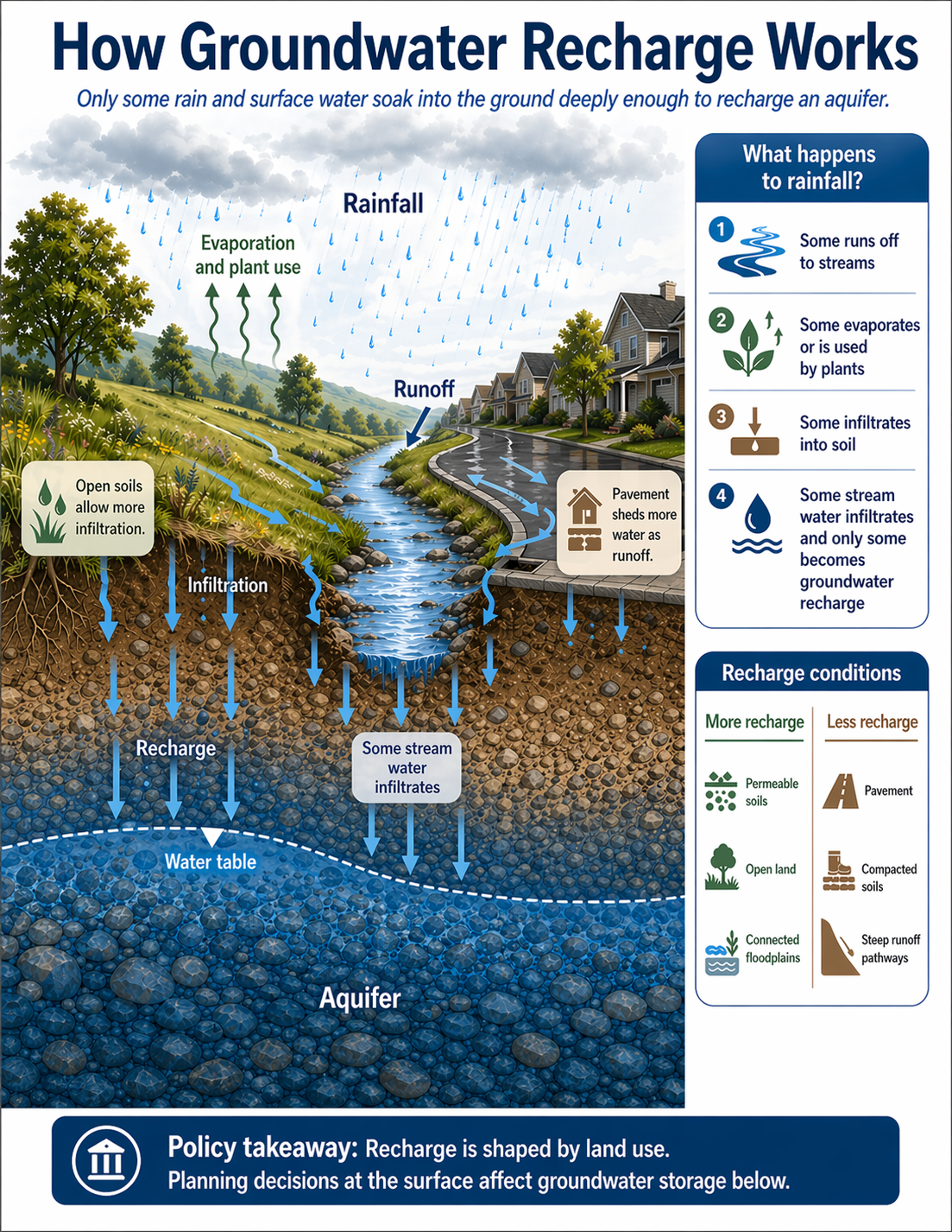
What the visual shows
The visual shows rainfall falling across a landscape with both open, vegetated land and paved areas.
On the vegetated side, more water can soak into the soil. Some of that water moves downward through pore spaces between soil and rock particles. If it reaches the water table, it becomes groundwater recharge.
The visual also shows a stream. Some stream water can infiltrate downward through the streambed and contribute to groundwater recharge, depending on streamflow, sediment, and local groundwater conditions.
On the paved side, more water runs off across the surface instead of soaking into the ground. Pavement, compacted soils, and steep runoff pathways can reduce infiltration and increase stormwater runoff.
The dashed line marks the water table. Recharge can cause the water table or groundwater level to rise where enough water reaches the aquifer.
Why recharge varies from place to place
Recharge is controlled by both surface conditions and subsurface geology.
At the surface, recharge depends on rainfall, snowmelt, streamflow, vegetation, land cover, soil condition, and slope. Open land and permeable soils generally allow more infiltration. Pavement and compacted soils generally produce more runoff.
Below the surface, recharge depends on the materials water must move through. Sand and gravel usually allow water to move more easily. Clay, silt, or dense rock can slow downward movement and limit recharge.
Recharge also varies over time. Wet seasons, snowmelt periods, storms, droughts, and changes in land use can all affect how much water reaches the aquifer.
Why this matters for policy
Understanding recharge helps policy staff evaluate whether groundwater use is sustainable. If groundwater is pumped faster than it is naturally replenished, groundwater levels can decline over time.
Recharge is also connected to land-use planning. Decisions about development, pavement, stormwater management, open space, floodplains, and soil disturbance can affect how much water reaches aquifers.
Recharge does not happen equally everywhere. A site that looks wet at the surface may not contribute much recharge if the water runs off quickly or if low-permeability layers block downward movement.
For managed aquifer recharge projects, natural recharge patterns help determine where recharge basins, stream-channel recharge, stormwater capture, or other approaches may be appropriate.
Key terms
Groundwater recharge
The process by which water moves from the surface down to an aquifer.
Infiltration
Water soaking into the soil or ground surface.
Percolation
Water moving downward through soil, sediment, or rock.
Runoff
Water that flows across the land surface into streams, storm drains, or other drainage pathways instead of soaking into the ground.
Evaporation
Water changing from liquid to vapor and returning to the atmosphere.
Plant use
Water taken up by plant roots and released back to the atmosphere through transpiration.
Water table
The upper surface of groundwater in an unconfined aquifer.
Aquifer
An underground layer of rock, sand, gravel, or sediment that can store and transmit groundwater.
Permeable soils
Soils or sediments that allow water to move through them relatively easily.
Compacted soils
Soils that have been pressed together, reducing pore space and limiting infiltration.
Questions policy staff can ask
- How much local groundwater recharge occurs naturally?
- Is groundwater being extracted faster than it is replenished?
- Which areas contribute most to recharge?
- Which land uses reduce infiltration or increase runoff?
- Are there floodplains, stream corridors, or open lands that support recharge?
- Do pavement, soil compaction, or drainage systems reduce recharge?
- What subsurface materials control whether water can reach the aquifer?
- How will changes in development, stormwater management, or climate affect recharge?
- Could managed aquifer recharge help supplement natural recharge?
- What monitoring is needed to track groundwater levels over time?
Policy takeaway
Surface decisions shape underground water availability.
Main concept: Only some rain and surface water soak into the ground deeply enough to recharge an aquifer.
Core message: The visual explains that rainfall does not all become groundwater. Some water runs off, some evaporates or is used by plants, some infiltrates into soil, and only some reaches the aquifer as recharge.
Main visual elements: The guide shows rainfall falling on a landscape with vegetation, open soils, pavement, a stream, the water table, and an aquifer below ground.
Rainfall pathways: The visual identifies four main outcomes for rainfall.
First, runoff: Some rainfall runs off the land surface and flows to streams.
Second, evaporation and plant use: Some water returns to the atmosphere through evaporation or is taken up by plants.
Third, infiltration: Some water soaks into the soil.
Fourth, stream infiltration: Some stream water infiltrates into the ground, but only some of that water becomes groundwater recharge.
Landscape conditions: The visual contrasts open soils and paved areas. Open soils allow more infiltration. Pavement sheds more water as runoff.
Recharge zone: Water that infiltrates deeply enough moves downward toward the water table and can recharge the aquifer.
Recharge conditions: The guide compares conditions that support more recharge with conditions that support less recharge.
More recharge: Permeable soils, open land, and connected floodplains can allow more water to soak into the ground.
Less recharge: Pavement, compacted soils, and steep runoff pathways can reduce infiltration and increase runoff.
Policy relevance: The visual shows that land-use decisions at the surface can affect how much water reaches groundwater storage below.
Policy takeaway: Recharge is shaped by land use. Planning decisions at the surface affect groundwater storage below.