
Why Flood Depth Is Not the Whole Story
Discusses why flood impacts depend on more than water depth alone.
Flood depth matters, but it is only one part of flood damage. Two floods with the same depth can have very different consequences depending on how fast the water is moving, how long it stays, what it carries, and what lies in its path.
This matters because policy and planning decisions can go wrong if flood conditions are reduced to a single number. A clearer understanding of flood impacts helps staff interpret hazard information, think more broadly about infrastructure vulnerability, and plan for multiple forms of damage.
Download or reuse this guide in briefings and meeting materials.
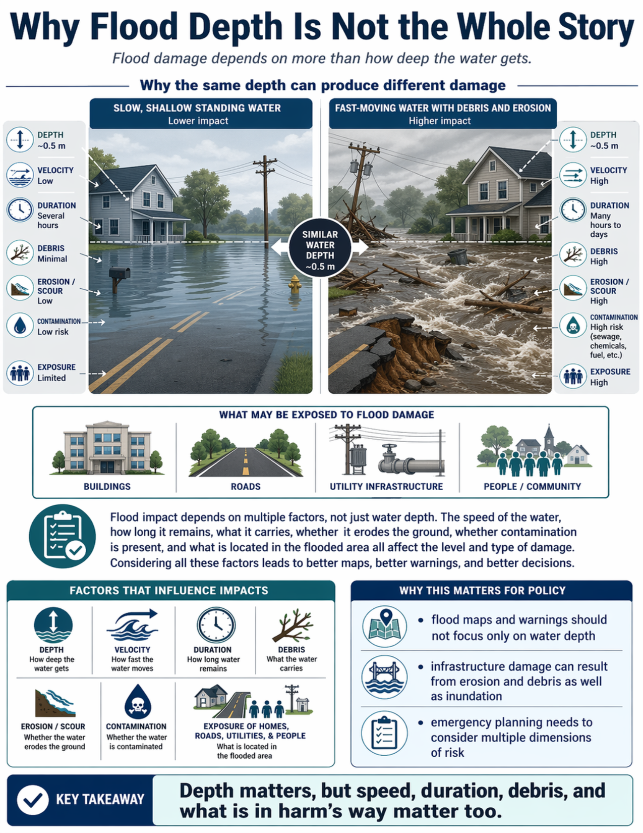
What the visual shows
The visual compares two flood situations with similar water depth—about half a meter—but different impacts.
On the left, the flood is shown as slow, shallow standing water around a home and road. Because the water is relatively still, the overall impact is lower. The guide labels this example as having low velocity, shorter duration, minimal debris, low erosion or scour, lower contamination risk, and limited exposure.
On the right, the water is shown moving quickly with debris, erosion, and stronger force. Even though the depth is similar, the impact is higher. The guide labels this example as having high velocity, longer duration, high debris, high erosion or scour, higher contamination risk, and greater exposure.
The visual also identifies what may be exposed to flood damage, including buildings, roads, utility infrastructure, and people or communities.
A final section summarizes the main factors that influence impacts:
- depth
- velocity
- duration
- debris
- erosion or scour
- contamination
- exposure of homes, roads, utilities, and people
Why this matters for policy
Flood maps, warnings, and planning discussions often focus heavily on depth. But infrastructure and community impacts can also depend on how fast the water moves, whether it erodes foundations or roads, whether it carries debris, and how long it remains in place.
This concept matters for emergency planning, infrastructure design, asset management, damage assessment, and public communication. It helps explain why a shallow but fast-moving flood can be highly destructive, and why similar depths can produce very different consequences in different places.
A broader view of flood impact supports better decision-making because it considers the full dimensions of hazard, exposure, and damage—not just inundation depth.
Key terms
Flood depth
How deep the water gets in a flooded area.
Velocity
How fast floodwater is moving.
Duration
How long floodwater remains in place.
Debris
Objects and material carried by floodwater, such as branches, vehicles, or other items.
Erosion or scour
The wearing away of soil, foundations, road edges, or other material by moving water.
Contamination
The presence of harmful substances in floodwater, such as sewage, chemicals, or fuel.
Exposure
The people, buildings, roads, utilities, and other assets located in the flooded area.
Questions policy staff can ask
- Are flood maps and risk discussions focusing too narrowly on water depth?
- How fast is the water expected to move in this area?
- How long might floodwater remain on site?
- Could roads, bridges, foundations, or utilities be damaged by erosion or scour?
- Is debris likely to increase damage during a flood?
- Are there contamination risks from sewage, chemicals, or fuel?
- What people and assets are exposed in the flooded area?
- How should emergency planning account for multiple dimensions of flood impact?
Policy takeaway
Depth matters, but speed, duration, debris, and what is in harm’s way matter too.
Main concept: Flood damage depends on more than how deep the water gets.
Main comparison: The visual compares two flood situations with similar water depth, about 0.5 meters, but very different impacts.
Lower-impact example: On the left, slow, shallow standing water surrounds a house and roadway. The labels indicate low velocity, several hours of duration, minimal debris, low erosion or scour, low contamination risk, and limited exposure.
Higher-impact example: On the right, fast-moving water with debris and erosion surrounds a house, roadway, and utility area. The labels indicate high velocity, many hours to days of duration, high debris, high erosion or scour, high contamination risk, and high exposure.
Exposed elements: A row of icons identifies buildings, roads, utility infrastructure, and people or community as things that may be exposed to flood damage.
Factors section: A section titled “Factors that influence impacts” lists depth, velocity, duration, debris, erosion or scour, contamination, and exposure of homes, roads, utilities, and people.
Policy relevance: The guide states that flood maps and warnings should not focus only on water depth, that infrastructure damage can result from erosion and debris as well as inundation, and that emergency planning needs to consider multiple dimensions of risk.
Key takeaway: Depth matters, but speed, duration, debris, and what is in harm’s way matter too.