
How Upstream Land Use Changes Downstream Flooding
Shows how upstream land use can change runoff, sediment movement, and flood peaks downstream.
Flooding at one location is often influenced by what happens elsewhere in the watershed. Land use upstream affects how quickly water runs off, how much sediment it carries, and how strongly flood peaks build as water moves downstream.
This matters because flooding is not shaped only by the place that floods. A clearer watershed perspective helps policy staff connect local flood impacts to broader decisions about land clearing, drainage, development, and infrastructure.
Download or reuse this guide in briefings and meeting materials.
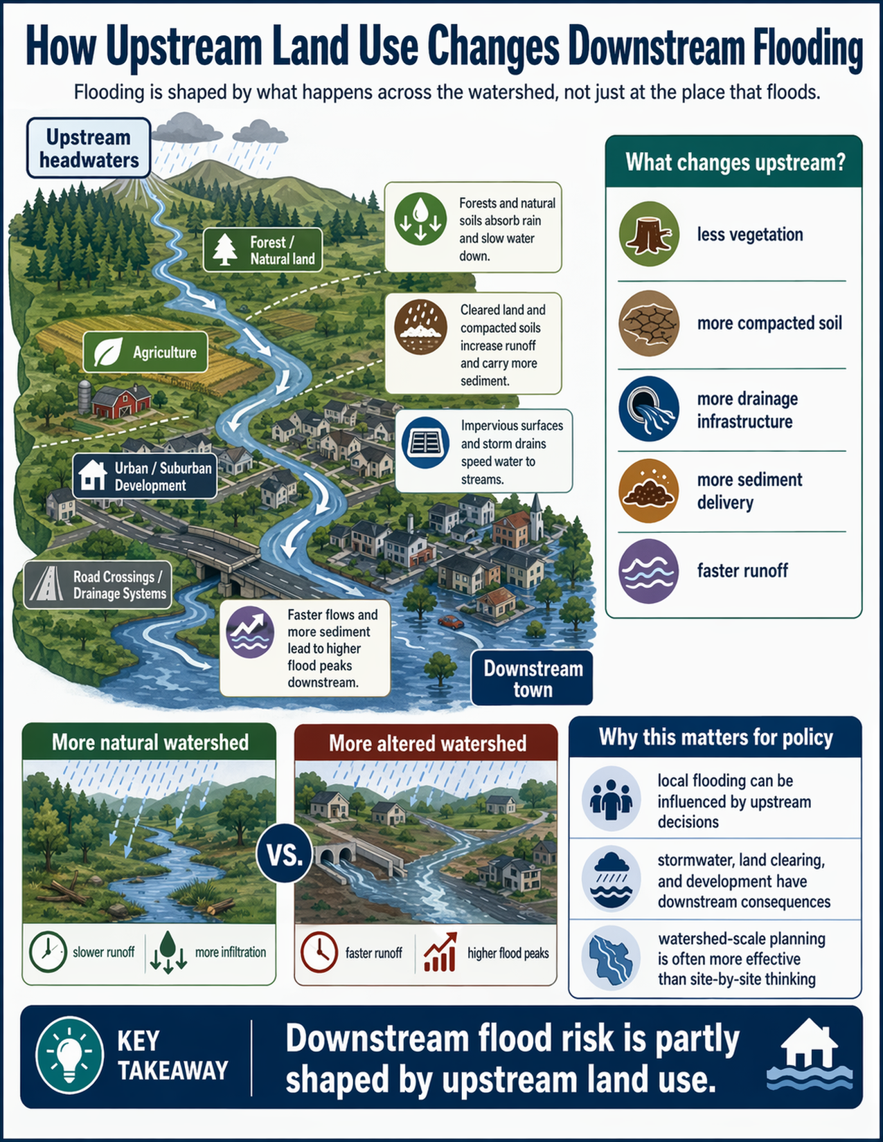
What the visual shows
The visual traces water from upstream headwaters to a downstream town.
In the upper watershed, forests and natural land absorb rainfall and slow water down. Farther downstream, agricultural land, cleared areas, and compacted soils produce more runoff and can carry more sediment into streams.
The guide then shows urban and suburban development, where impervious surfaces and storm drains move water more quickly into the channel. Road crossings and drainage systems also help route water downstream.
At the bottom of the watershed, the visual shows a downstream town experiencing flooding. The guide highlights that faster flows and more sediment can contribute to higher flood peaks downstream.
A comparison panel contrasts a more natural watershed with a more altered watershed. The more natural watershed is shown with slower runoff and more infiltration. The more altered watershed is shown with faster runoff and higher flood peaks.
The guide also identifies common upstream changes that matter:
- less vegetation
- more compacted soil
- more drainage infrastructure
- more sediment delivery
- faster runoff
Why this matters for policy
Flooding is often managed as if it were only a site-level issue. But many local flood problems are shaped by decisions made elsewhere in the watershed.
That means land clearing, stormwater design, drainage systems, road crossings, and development patterns can all have downstream consequences. Even when no single upstream action causes a flood by itself, many small changes across a watershed can add up to larger downstream impacts.
This concept matters for watershed planning, stormwater policy, infrastructure design, land-use review, and resilience planning. It supports a broader view of flood management that looks beyond individual parcels or isolated projects.
Key terms
Watershed
The land area where precipitation drains to a common stream, river, lake, or other outlet.
Runoff
Water that flows over land rather than soaking into the ground.
Infiltration
The process of water soaking into soil or other geologic materials.
Impervious surface
A surface, such as pavement or rooftops, that prevents or greatly reduces infiltration.
Sediment delivery
The movement of eroded soil and other particles into streams and rivers.
Flood peak
The highest flow or water level reached during a flood event.
Questions policy staff can ask
- What upstream land uses influence flooding in this area?
- Are forests, soils, and natural drainage areas being reduced or altered?
- How much runoff is being accelerated by pavement, storm drains, or road crossings?
- Are upstream projects being reviewed only site by site, or at the watershed scale?
- Is sediment delivery affecting channel capacity or downstream flood behavior?
- Are there opportunities to slow water down or increase infiltration upstream?
- How are stormwater and land-use decisions being coordinated across jurisdictions?
- Are downstream communities bearing the effects of upstream development choices?
Policy takeaway
Downstream flood risk is partly shaped by upstream land use.
Main concept: Flooding is shaped by what happens across the watershed, not just at the place that floods.
Main illustration: The visual shows an upstream-to-downstream watershed. It begins in upstream headwaters with forests and natural land, then moves through agriculture, urban and suburban development, and road crossings or drainage systems, and ends in a downstream town.
Land-use effects: Forest and natural land are shown absorbing rain and slowing water down. Agriculture is shown as carrying more runoff and sediment. Urban and suburban development are shown with impervious surfaces and storm drains that move water quickly to streams. Road crossings and drainage systems are shown routing water downstream.
Upstream changes: A side panel titled “What changes upstream?” lists less vegetation, more compacted soil, more drainage infrastructure, more sediment delivery, and faster runoff.
Watershed comparison: The visual compares a more natural watershed with a more altered watershed. The more natural watershed has slower runoff and more infiltration. The more altered watershed has faster runoff and higher flood peaks.
Policy relevance: The guide notes that local flooding can be influenced by upstream decisions, that stormwater, land clearing, and development have downstream consequences, and that watershed-scale planning is often more effective than site-by-site thinking.
Key takeaway: Downstream flood risk is partly shaped by upstream land use.