
Why Floodplains Exist
Explores how floodplains, which are natural parts of river systems, form over time as rivers overflow, slow down, deposit sediment, and shift across the landscape.
Floodplains are not just leftover open land beside rivers. They are part of the river system itself, created over time as rivers overflow, slow down, deposit sediment, and shift across the landscape.
This matters because floodplains perform important natural functions. Understanding how they form helps policy staff connect flood behavior to land use, infrastructure, ecosystem protection, and long-term resilience.
Download or reuse this guide in briefings and meeting materials.
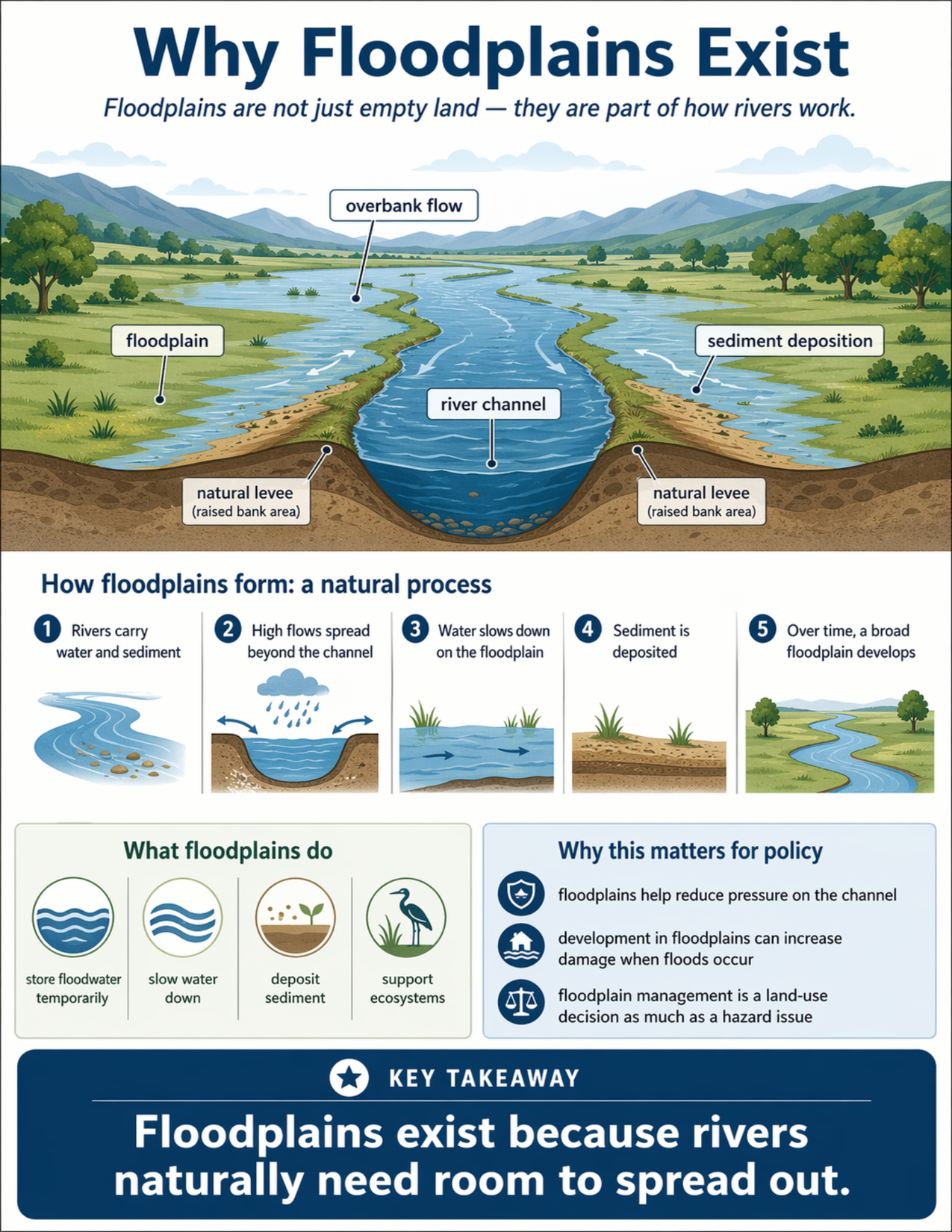
What the visual shows
The visual shows a river channel flowing through a broad valley with floodplain areas on both sides. Labels identify the river channel, floodplain, overbank flow, sediment deposition, and natural levee or raised bank areas near the channel.
The guide explains that floodplains form through a natural process. Rivers carry both water and sediment. During higher flows, water spreads beyond the channel onto adjacent land. Once water moves onto the floodplain, it slows down. As it slows, it deposits some of the sediment it was carrying. Over time, repeated flooding and deposition help build a broad floodplain.
The visual also highlights what floodplains do. They can store floodwater temporarily, slow water down, deposit sediment, and support ecosystems.
Why this matters for policy
Floodplains are part of how rivers reduce pressure during higher flows. When rivers have room to spread out, some of the water can be stored temporarily across the floodplain rather than remaining fully confined to the channel.
This has direct implications for planning and development. Building in floodplains can increase damage when floods occur because people, homes, roads, and infrastructure are placed in areas where water naturally goes.
The concept also matters because floodplain management is not only a hazard issue. It is also a land-use issue. Decisions about where growth occurs, what gets built, and how rivers are managed affect how communities experience flood impacts.
Key terms
Floodplain
The relatively flat land beside a river that can be inundated when water rises beyond the channel.
River channel
The lower part of the river system where water normally flows.
Overbank flow
Water that exceeds the channel and spreads onto the floodplain.
Sediment deposition
The settling of sand, silt, or other material when flowing water slows down.
Natural levee
A slightly raised bank area near the river channel formed by repeated sediment deposition during floods.
Land-use decision
A policy or planning decision about how land is used, developed, protected, or managed.
Questions policy staff can ask
- Where are the active floodplain areas in this watershed?
- How much development is located in places where rivers naturally spread out?
- Are current land-use decisions increasing future flood damage?
- How do floodplain areas help reduce pressure on the river channel?
- What natural floodplain functions have been reduced or disconnected?
- Are floodplain management policies being treated only as emergency issues, or also as planning issues?
- How should infrastructure placement account for natural overflow space?
- What tradeoffs exist between development, flood storage, and ecosystem function?
Policy takeaway
Floodplains exist because rivers naturally need room to spread out.
Main concept: Floodplains are not just empty land. They are part of how rivers work.
Main illustration: The visual shows a river channel in the center of a broad valley. Labels identify the floodplain, overbank flow, river channel, sediment deposition, and natural levee or raised bank areas on both sides of the channel.
Process explanation: A section titled “How floodplains form: a natural process” explains five steps. First, rivers carry water and sediment. Second, high flows spread beyond the channel. Third, water slows down on the floodplain. Fourth, sediment is deposited. Fifth, over time, a broad floodplain develops.
Floodplain functions: The visual explains that floodplains store floodwater temporarily, slow water down, deposit sediment, and support ecosystems.
Policy relevance: The guide notes that floodplains help reduce pressure on the channel, that development in floodplains can increase damage when floods occur, and that floodplain management is a land-use decision as much as a hazard issue.
Key takeaway: Floodplains exist because rivers naturally need room to spread out.