
How Earth Fissures Form
Explains how earth fissures can form where uneven subsidence stretches basin-fill sediments, and why these cracks matter for infrastructure and land-use planning.
Earth fissures are long cracks or openings in the ground surface. They commonly form where land subsides unevenly and the ground is pulled apart.
This matters for policy because a visible fissure is often a sign of a broader subsidence problem, not just an isolated crack. Groundwater management, subsidence monitoring, hazard mapping, drainage control, and infrastructure planning can help reduce long-term damage.
Download or reuse this guide in briefings and meeting materials.
How Earth Fissures Form
Earth fissures are long cracks or openings in the ground surface. They commonly form where the land surface is pulled apart by uneven subsidence.
Subsidence means the land surface sinks. When that sinking happens unevenly, the ground can stretch, crack, and open into a fissure.
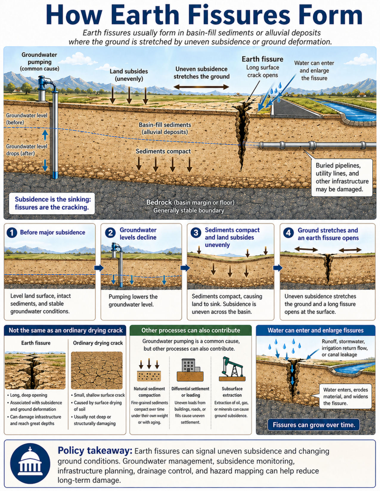
What the visual shows
The visual shows a broad basin or valley floor in cross-section. Basin-fill sediments, also called alluvial deposits, sit above a more stable bedrock boundary.
A groundwater pumping well is shown on one side of the basin. Pumping lowers the groundwater level. As groundwater levels decline, some water-bearing sediments compact. This compaction can lower the land surface.
The land does not always sink evenly. Some areas may subside more than others because sediment thickness, sediment type, groundwater decline, and the shape of the basin vary from place to place. Where the ground is stretched by uneven subsidence, a long surface crack can open. This is an earth fissure.
The visual also shows roads, canals, pipelines, utility lines, and other infrastructure near the fissure. These features can be damaged when the ground opens, shifts, or erodes.
A four-step sequence explains the process:
- Before major subsidence, the land surface is level and groundwater conditions are stable.
- Groundwater levels decline, often because of pumping.
- Sediments compact, and the land subsides unevenly.
- The ground stretches, and an earth fissure opens at the surface.
The visual also compares earth fissures with ordinary drying cracks. Earth fissures are usually longer, deeper, and more hazardous. Ordinary drying cracks are small, shallow surface cracks caused by soil drying and shrinking.
Another panel explains that groundwater pumping is a common cause, but other processes can also contribute. These include natural sediment compaction, uneven loading from buildings, roads, or fill, and subsurface extraction of oil, gas, or minerals.
A final panel shows that water can enter a fissure. Runoff, stormwater, irrigation return flow, or canal leakage can erode material and widen the opening. This means fissures can grow over time.
Why this matters for policy
Earth fissures matter because they can damage infrastructure and signal a larger subsidence problem. A visible fissure is often not just an isolated crack. It may be the surface expression of deeper ground deformation.
Groundwater pumping can contribute to earth fissure formation by lowering groundwater levels. When groundwater levels fall, fine-grained sediments can compact. If different parts of a basin compact by different amounts, the land surface may sink unevenly. That uneven sinking can stretch the ground and open fissures.
Earth fissures often occur in sediment-filled basins. They are especially common near basin margins or where soft sediments meet more stable rock. These areas can experience sharp differences in how much the land subsides.
Earth fissures can affect roads, canals, pipelines, foundations, utilities, rail lines, drainage systems, agricultural fields, and developed areas. They can create safety hazards, disrupt transportation, expose buried infrastructure, and increase maintenance costs.
Water can make fissures worse. Once a fissure opens, water can enter through the crack and erode soil. Heavy rain, stormwater runoff, irrigation return flow, and canal leakage can enlarge the fissure and make damage more visible.
Fissures may grow gradually over time. They may also become more obvious after heavy rain, irrigation, continued groundwater decline, or continued land subsidence.
Policy staff may need to consider earth fissures in groundwater planning, infrastructure siting, development review, hazard mapping, road maintenance, canal operations, utility planning, and public communication.
Key terms
Earth fissure
A long crack or opening in the ground surface, commonly associated with uneven subsidence or ground deformation.
Subsidence
The sinking or lowering of the land surface.
Uneven subsidence
Subsidence that occurs at different rates in different places. Uneven subsidence can stretch the ground and contribute to fissure formation.
Groundwater decline
A lowering of groundwater levels. This can happen when groundwater is pumped faster than it is replenished.
Groundwater pumping
Withdrawal of groundwater from wells for uses such as agriculture, municipal supply, industry, or domestic water.
Sediment compaction
The squeezing together of sediment grains. Compaction can occur when groundwater levels decline and sediments lose support.
Basin-fill sediments
Loose or weakly consolidated sediments that fill a basin or valley. These may include clay, silt, sand, and gravel deposited by rivers, streams, or other processes.
Alluvial deposits
Sediments deposited by flowing water, commonly found in valleys, floodplains, fans, and basins.
Basin margin
The edge of a sediment-filled basin, often where softer basin sediments meet more stable rock.
Desiccation crack
A small surface crack caused by soil drying and shrinking. Desiccation cracks are usually shallower and smaller than earth fissures.
Differential settlement
Uneven sinking caused by differences in ground materials, loading, compaction, or support.
Subsurface extraction
Removal of underground materials or fluids, such as oil, gas, minerals, or groundwater. Some forms of extraction can contribute to subsidence.
Runoff
Water that flows over the land surface after rain, snowmelt, irrigation, or other water input.
Hazard mapping
Mapping that identifies where hazards or hazard-related conditions may be present.
Questions policy staff can ask
- Are earth fissures known or suspected in this area?
- Is the site in a sediment-filled basin or near a basin margin?
- Are soft basin-fill sediments present above more stable bedrock?
- Has groundwater pumping lowered groundwater levels in the area?
- Is land subsidence being measured or monitored?
- Is subsidence uneven across the basin or near the project site?
- Are fissures mapped, and are the maps current?
- Are roads, canals, pipelines, utilities, rail lines, foundations, or drainage systems located near known fissures?
- Could runoff, stormwater, irrigation return flow, or canal leakage enter an existing fissure?
- Are drainage controls needed to keep water from enlarging fissures?
- Could the fissure affect emergency routes, water delivery, utility service, or public access?
- Are site investigations needed before new development or infrastructure repair?
- Does groundwater management planning account for subsidence and fissure risk?
- How should the public be informed that a visible fissure may indicate broader ground deformation?
Policy takeaway
Earth fissures are signs of deeper ground deformation, often linked to uneven subsidence. Groundwater management, hazard mapping, drainage control, and infrastructure planning can help reduce long-term damage and disruption.
Main concept: Earth fissures are long cracks or openings in the ground surface that commonly form where uneven subsidence stretches the ground.
Core message: Earth fissures are signs of deeper ground deformation. They are often linked to uneven subsidence in sediment-filled basins, especially where groundwater pumping lowers groundwater levels and allows sediments to compact.
Main visual: The main panel shows a basin or valley floor with basin-fill sediments above a generally stable bedrock boundary. A groundwater pumping well lowers the groundwater level, sediments compact, and land subsides unevenly. Where the ground is stretched, a long earth fissure opens in the sediment layer.
Infrastructure: The visual shows roads, canals, buried pipelines, utility lines, and other infrastructure near the fissure. These assets may be damaged if the ground opens, shifts, or erodes.
Process sequence: A four-step sequence shows conditions before major subsidence, groundwater levels declining, sediments compacting and land subsiding unevenly, and the ground stretching until an earth fissure opens.
Drying cracks comparison: The visual compares earth fissures with ordinary drying cracks. Earth fissures are deeper, longer, and associated with subsidence and ground deformation. Drying cracks are usually shallow surface cracks caused by soil shrinkage.
Other contributing processes: Groundwater pumping is a common cause, but natural sediment compaction, differential settlement or loading, and subsurface extraction can also contribute to ground deformation.
Water entry: Runoff, stormwater, irrigation return flow, or canal leakage can enter a fissure, erode material, and widen the opening over time.
Policy takeaway: Earth fissures are signs of deeper ground deformation, often linked to uneven subsidence. Groundwater management, hazard mapping, drainage control, and infrastructure planning can help reduce long-term damage and disruption.