
When the Ground Has Hidden Voids
Explains how hidden underground voids can form naturally or through human activity and lead to settlement, cracking, or collapse at the surface.
Some land-instability problems begin below the surface. Underground openings can form naturally or through human activity, and the ground above them may settle, crack, sag, or collapse when support is lost.
This matters for policy because void-related hazards may not be visible at the surface until damage begins. Development review, infrastructure maintenance, stormwater controls, local records, mapping, and geotechnical investigation can help identify hidden conditions before they become costly problems.
Download or reuse this guide in briefings and meeting materials.
When the Ground Has Hidden Voids
Some land-instability problems begin below the surface. Underground openings can form naturally or through human activity, and the ground above them may settle, crack, sag, or collapse when support is lost.
These hazards can be difficult to recognize because the surface may look stable until damage begins. Development and infrastructure decisions should consider what may be happening underground, not only what is visible at the surface.
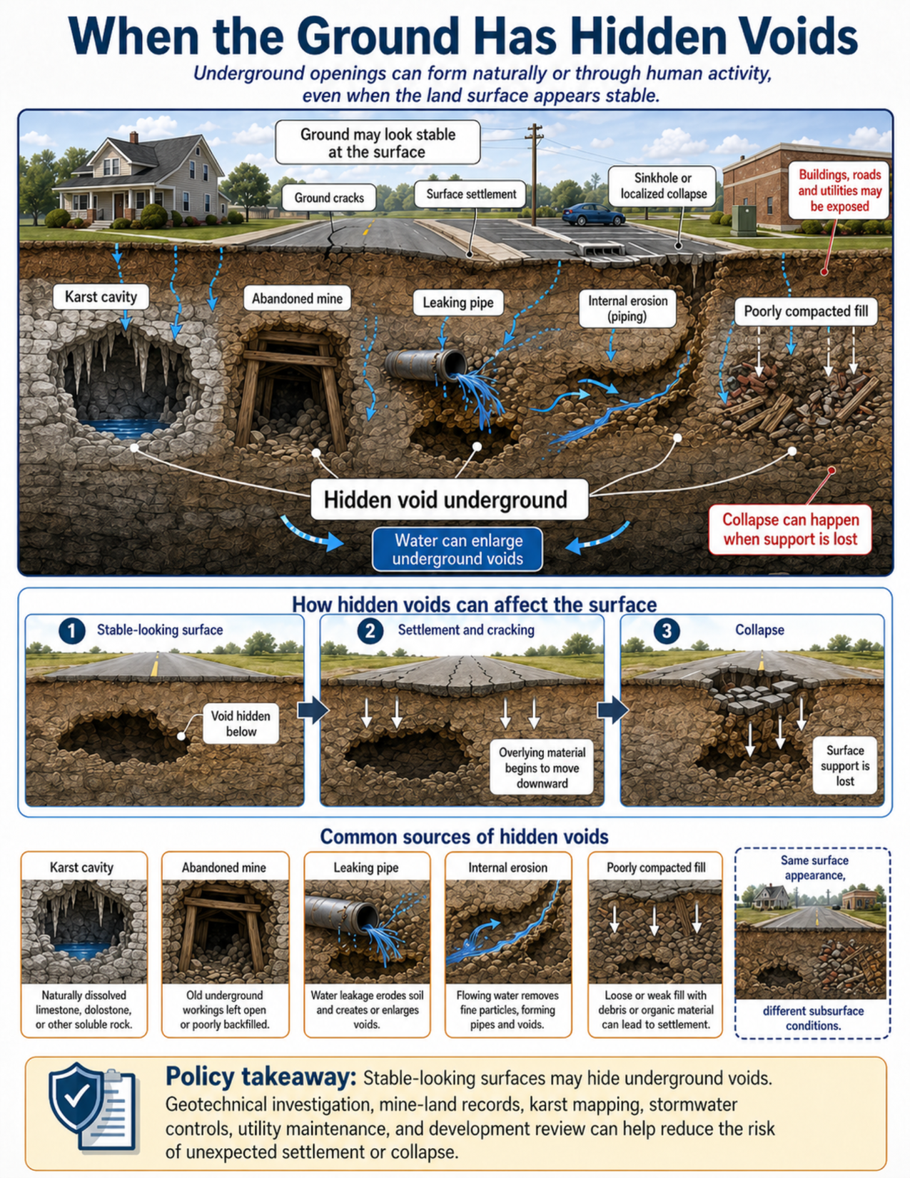
What the visual shows
The visual shows a stable-looking surface with a house, road, parking area, building, storm drain, and utilities. Below the surface, a cross-section shows several kinds of hidden underground openings or weak zones.
One example is a karst cavity, which can form where groundwater dissolves soluble rock such as limestone or dolostone. Another example is an abandoned mine, where old underground workings may be left open, collapse over time, or be poorly backfilled.
The visual also shows a leaking pipe washing away soil underground. Nearby, internal erosion, also called piping, occurs where flowing water removes fine particles and creates small underground channels. Over time, these channels can enlarge and reduce support for the surface above.
A separate area shows poorly compacted fill, where loose or unevenly placed material, buried debris, or weak zones can settle later. This is not always a clean open void, but it can still reduce support and lead to surface settlement.
The sequence panel shows how hidden voids can affect the surface. First, the road appears stable while a void is hidden below. Next, the overlying material begins to move downward, causing settlement and cracking. Finally, surface support is lost and a localized collapse occurs.
Why this matters for policy
Hidden voids can threaten buildings, roads, utilities, parking areas, stormwater systems, drainage structures, and other infrastructure. These problems may not be obvious during a surface inspection, especially before settlement or cracking begins.
Water often plays an important role. It can dissolve rock in karst terrain, wash away soil around leaking pipes, move fine particles through internal erosion, and enlarge underground openings. Stormwater systems, drainage patterns, irrigation, leaking infrastructure, and utility failures can all affect subsurface stability.
Void-related hazards can come from both natural and human sources. Natural examples include karst cavities and lava tubes. Human-related examples include abandoned mines, leaking pipes, poorly compacted fill, buried debris, utility failures, and excavation-related weak zones.
Policy staff may need to consider records and information that are not visible on the ground surface. Local mine records, karst maps, utility inspection reports, stormwater system records, development history, and geotechnical investigations can all help identify areas of concern.
Stormwater controls and utility maintenance can reduce the chance that water will worsen underground instability. Development review may also need to require site-specific investigation where hidden voids, mine workings, karst terrain, buried debris, or weak fill are possible.
Key terms
Hidden void
An underground opening or unsupported space that may not be visible at the surface.
Karst cavity
An underground opening formed where water dissolves soluble rock such as limestone, dolostone, or gypsum.
Soluble rock
Rock that can dissolve in water over time. Limestone, dolostone, and gypsum are common examples.
Lava tube
A natural tunnel formed by flowing lava in volcanic terrain. Some lava tubes can create underground openings that affect surface stability.
Abandoned mine
Old underground mine workings that may remain open, collapse, or be poorly filled after mining stops.
Internal erosion
The movement of soil particles by flowing water inside the ground. It can create small channels that reduce support.
Piping
A form of internal erosion where water flow creates pipe-like channels through soil or fill.
Leaking infrastructure
Buried pipes, culverts, drains, or other infrastructure that leak water into the ground and may wash away soil or weaken support.
Poorly compacted fill
Placed soil, rubble, or other material that was not compacted evenly or strongly enough. It may settle later under weight, water, or vibration.
Buried debris
Old construction debris, organic material, waste, or rubble buried below the surface. It can create weak zones or settle unevenly.
Settlement
Downward movement of the ground surface. Settlement may appear as sagging pavement, cracked walls, uneven floors, or lowered ground.
Sinkhole
A closed depression or collapse at the ground surface, often associated with underground voids, karst terrain, or soil being washed downward.
Geotechnical investigation
A technical study of soil, rock, groundwater, fill, and subsurface conditions to support planning, engineering, or permitting decisions.
Questions policy staff can ask
- Could hidden underground voids or weak zones be present at this site?
- Is the area underlain by karst terrain, soluble rock, lava tubes, or known natural cavities?
- Are there abandoned mines, mine-land records, or old excavation areas nearby?
- Are there buried utilities, culverts, storm drains, or pipes that could leak or wash soil away?
- Is there evidence of internal erosion, piping, seepage, or unexplained soil loss?
- Was the site built on fill, buried debris, reclaimed land, or previously disturbed ground?
- Are there surface clues such as cracks, sagging pavement, settlement, depressions, or repeated repairs?
- Could stormwater, irrigation, leaking pipes, or drainage changes enlarge underground openings?
- Are local karst maps, mine maps, utility records, or development records available?
- Is a geotechnical investigation needed before permitting, construction, repair, or redevelopment?
- Do stormwater controls and utility maintenance plans reduce the chance that water will worsen underground instability?
- Does the development review process consider subsurface conditions, not just the surface appearance of the site?
Policy takeaway
Land can fail from below as well as from above, which is why development and infrastructure decisions should account for hidden underground conditions, not just surface appearance.
Main concept: Land can fail from below as well as from above.
Core message: Underground voids can form naturally or through human activity. If the ground above a void loses support, the surface may settle, crack, sag, or collapse even when it looked stable beforehand.
Main visual: The visual shows a house, road, parking area, building, storm drain, and utility features at the surface. Below the surface are several hidden underground conditions, including a karst cavity, abandoned mine, leaking pipe, internal erosion, and poorly compacted fill.
Natural voids: Karst cavities can form where groundwater dissolves soluble rock such as limestone or dolostone. Lava tubes are another natural underground opening in some volcanic terrains.
Human-related voids: Voids or weak zones can form from abandoned mines, leaking buried pipes, internal erosion, poorly compacted fill, buried debris, and utility failures.
Surface effects: The visual shows ground cracks, surface settlement, and localized collapse as possible surface clues. These signs may appear only after subsurface support has already been weakened.
Water connection: Water can dissolve rock, wash away soil, move fine particles, enlarge underground openings, and worsen instability.
Policy connection: Local records, karst maps, mine maps, utility inspections, stormwater controls, development review, and geotechnical investigations can help identify areas where hidden voids or weak subsurface conditions may be present.
Policy takeaway: Land can fail from below as well as from above, which is why development and infrastructure decisions should account for hidden underground conditions, not just surface appearance.