Collection

Policy Briefs

Downloadable policy-facing briefs and case studies that translate geoscience issues into practical decision support.

"

Collection Items

Browse the items included in this collection.

20 results

Brief 2019-10-28

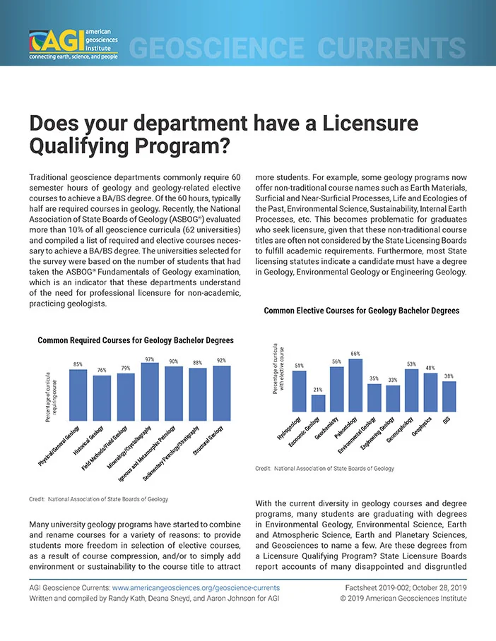
Does your department have a Licensure Qualifying Program?

Traditional geoscience departments require 60 semester hours of geology and geology-related courses, but many universities are combining and renaming courses, which can lead to graduates not meeting licensure requirements. To address this issue, faculty in geoscience departments need to align their curricula with the requirements of the workforce, as identified by occupational/task surveys conducted by ASBOG. By doing so, degree programs can ensure that students receive adequate academic training and are better prepared for a career in geology.

Policy Resources
Brief 2019-10-25

How do geologists make a living in 2019?

Geologists make up a small percentage of the global workforce, but their work has a significant impact on nearly every aspect of modern society. Most geology graduates find employment in three broad sectors: environmental remediation and management, natural resource discovery and utilization, and engineering and construction. Geologists use their special knowledge to benefit others, with many working behind the scenes to support critical infrastructure and resources that underpin civilization.

Policy Resources
Brief 2019-08-23

Tantalum

Tantalum is a rare metal used in electronics and other industries due to its high melting point and biocompatibility. It does not occur naturally in metallic form but is found in oxide minerals and pegmatites. The majority of world production is used in the electronics industry, while the remainder is consumed by chemical and metallurgical industries.

Policy Resources
Brief 2018-08-28

Present Day Climate Change

The Earth's climate has been warming due to the increasing levels of greenhouse gases in the atmosphere, primarily carbon dioxide and methane, which absorb infrared radiation and trap heat. This warming trend is observed over at least 30 years and is measured by various indicators such as temperature records, sea level rise, and changes in weather patterns. The evidence for climate change comes from multiple lines of research, including paleoclimatology, satellite observations, and field measurements.

Policy Resources
Brief 2018-08-06

Rip Currents and Beach Access Management

Rip currents are fast-moving currents that form on beaches with breaking waves, posing significant risks to beachgoers. The geophysical processes creating rip currents may also shape coastlines, often encouraging beach access and development in rip-prone areas. Coastal geomorphologists can provide critical insights into rip current formation and movement, helping policymakers, developers, and lifeguards make informed decisions about beach access points, lifeguard placement, no-swimming zones, and public education efforts.

Policy Resources
Brief 2018-08-06

Mapping Rip Currents at the Beach

Rip currents pose a significant threat to swimmers, but new technologies are being developed to improve our ability to map beach bathymetry and predict rip current locations. Lidar-based mapping and satellite imaging are being used to create highly specific forecasts and warnings for the public. These advancements have the potential to make beach safety efforts more effective and efficient.

Policy Resources
Brief 2018-04-19

Using Geologic Maps to Reduce Landslide Risk

Geologic maps are crucial in understanding landslide risk and can help make decisions on safety, infrastructure, and land use. Landslides occur when soil, rock, and surface debris are moved down a slope by gravity, and geologists plot various factors to determine areas most susceptible to landslides. Mapping major landslides and using this information can inform evacuation plans, reduce risk to lives and property, and improve public safety.

Policy Resources
Brief 2018-04-09

Geologic Mapping and the Trans-Alaska Pipeline

The Trans-Alaska Pipeline was designed with geologic mapping in mind to mitigate earthquake damage, as it crosses the Denali fault where a major earthquake could cause pipeline rupture and oil spills. Geologists mapped the area prior to construction, identifying potential hazards and designing a slider system that allows the pipeline to slide on steel beams during an earthquake, preventing damage and spills. The 2002 magnitude 7.9 earthquake on the Denali fault tested this design, with the pipeline surviving minor damage despite intense ground shaking.

Policy Resources
Brief 2018-04-04

Geologic Mapping and Public Health

Geologic maps can be used to identify naturally occurring hazardous materials such as radon and asbestos, which can pose health risks to surrounding communities. The USGS has been working with the North Dakota Geological Survey to map erionite, a type of naturally occurring asbestos that was found in aggregate used for road construction, leading to increased awareness and precautions being taken to protect public health. By mapping these hazards, geologists can help decision-makers determine areas at risk and inform protocols for protecting residents.

Policy Resources
Brief 2018-03-30

Geologic Mapping for the Nation

The National Cooperative Geologic Mapping Program (NCGMP) coordinates Federal, State, and academic programs to provide detailed geologic maps for land-use planning, resource identification, and natural hazard avoidance. The program has three components: FEDMAP, STATEMAP, and EDMAP, which work together to create high-quality geologic maps and train the next generation of geologic mappers. NCGMP's goal is to address the nationwide need for detailed geologic mapping and provide comprehensive, multi-resolution, three-dimensional digital information.

Policy Resources
Brief 2018-02-26

Earthquake Hazards near the New Madrid Fault Zone

The New Madrid Fault Zone (NMFZ) in the central United States is a region prone to large earthquakes that can cause significant damage and disruption to infrastructure, transportation networks, and industries. The area's unique geology makes it particularly vulnerable to intense groundshaking, landslides, and surface uplift, posing a risk to buildings, bridges, levees, dams, and other critical infrastructure. To mitigate this risk, the region needs to adopt earthquake-resistant building codes, consider site selection and land-use planning, and increase awareness of earthquake hazards and risks.

Policy Resources
Brief 2017-12-07

Valley Fever - A Health Hazard in Southwestern Dust

Valley fever, or coccidioidomycosis, is a respiratory illness caused by inhaling spores of the <em>Coccidioides</em> fungus, prevalent in arid regions of the southwestern United States. The fungus thrives in well-drained, fine sandy soils with distinct wet and dry seasons, and its spores can become airborne when soil surfaces are disturbed by activities such as construction, agriculture, or natural events like windstorms. Understanding the environmental conditions that promote the growth of <em>Coccidioides</em> and the processes that release its spores into the air is crucial for managing and mitigating valley fever risks to public health.

Policy Resources
Brief 2017-09-25

Managed aquifer recharge in California

California's four well-established water districts - Santa Clara Valley, Orange County, Water Replenishment District of Southern California, and Kern Water Bank Authority - use managed aquifer recharge (MAR) to stabilize groundwater levels and increase water supply. MAR involves recharging groundwater aquifers with excess water from rivers, reservoirs, or stormwater runoff during wet periods, reducing the need for groundwater pumping during dry periods. The success of MAR depends on having a suitable aquifer, regulatory framework, and proper management.

Policy Resources
Brief 2017-09-25

Managed Aquifer Recharge

Managed aquifer recharge (MAR) is a water management method that recharges an aquifer using either surface or underground techniques, providing a reliable source of water during droughts. MAR can be done through surface infiltration and deep injection methods, which use various sources such as river water, stormwater, and treated wastewater to replenish the aquifer. The technique has both positive and negative effects on groundwater quality, depending on the water source and MAR method used.

Policy Resources
Brief 2017-09-07

Dry well usage across the United States

Dry wells are used to improve stormwater drainage and aquifer recharge by providing a fast route for rainwater to drain deep into underlying sediment and rock. The US Environmental Protection Agency (EPA) regulates dry wells through the underground injection control program, with states having primacy over their programs in some cases. States have varying regulations due to different geologic conditions, such as precipitation levels, water tables, and bedrock depth, which influence the need for regulation and monitoring of dry well operations.

Policy Resources
Brief 2017-09-07

Dry wells for stormwater management

Dry wells are underground structures that capture surface water and transmit it to aquifers, reducing stormwater runoff's impact on streams and rivers. When used properly with pretreatment and in suitable locations, dry wells can recharge groundwater supplies and mitigate drought or excessive extraction risks. However, improper use or installation can lead to groundwater contamination, highlighting the importance of careful design, siting, and monitoring.

Policy Resources
Brief 2017-07-13

Roadway deicing in the United States

Roadway deicing in the U.S. relies primarily on sodium chloride (rock salt) for its affordability and effectiveness, with domestic salt production rising significantly from 1940 to 1970 due to its widespread use on the Interstate Highway System. However, rock salt loses effectiveness below 10°F (-12.2°C) and raises environmental concerns like water contamination and infrastructure corrosion. Alternatives such as calcium chloride and magnesium chloride are used in colder conditions, though they come with their own environmental and economic trade-offs.

Policy Resources
Brief 2017-03-31

Investigating Volcanic Landslide Hazards

Modern tools are being used to improve risk assessment for volcanic landslides and debris flows, which can be just as dangerous as eruptions. Helicopter electromagnetic mapping is being used to create detailed maps of the thickness of ice, distribution of groundwater, alteration of rock, and thickness of debris on volcanoes like Mount Rainier, Mount Adams, and Mount Baker in Washington state. This technology provides much-needed data for assessing flood and lahar hazards and improving community resilience and preparedness.

Policy Resources
Brief 2017-03-31

Recycling as a source of mineral commodities

Recycling is a crucial practice that helps conserve resources, reduce waste, and decrease energy consumption. It provides a significant source of essential metals, with 85% of used automobiles being recycled, and saves enough energy to power tens of millions of homes. However, there are limitations to recycling, including lag times, dissipation, cost, and quality issues, which affect the efficacy of recycling for certain materials.

Policy Resources
Brief 2017-03-09

Groundwater use in the United States

Groundwater provides 25% of the fresh water used in the United States, but its sustainability challenges are significant due to high demand and slow replenishment in arid areas. The Ogallala Aquifer, the largest aquifer in the US, is being rapidly depleted for irrigation, with water levels dropping by over 150 feet in parts of Texas and Kansas. Groundwater accounts for around 40% of US fresh water consumption, but its use is often unsustainable due to high evaporation rates and lack of replenishment.

Policy Resources