
What Is Debris Flow and Why It Moves So Fast?
Explains that debris flows are fast-moving mixtures of water, sediment, rock, vegetation, and debris that can travel quickly through channels and threaten people and infrastructure downslope.
A debris flow is not just muddy water. It is a fast-moving mixture of water, sediment, rocks, mud, vegetation, and debris that can begin on steep slopes or in small drainage areas during intense rainfall.
This matters for land-use and emergency-management policy because debris flows can travel quickly through channels and reach roads, culverts, bridges, homes, and evacuation routes downslope, even beyond the steep areas where they begin.
Download or reuse this guide in briefings and meeting materials.
What Is Debris Flow and Why It Moves So Fast?
A debris flow is not just muddy water. It is a fast-moving mixture of water, sediment, rocks, mud, vegetation, and other debris that can travel downslope through channels and drainage paths.
Debris flows often begin during intense rainfall, especially where loose material is available on steep slopes or in small watersheds. Because channels and gullies can concentrate the moving mixture, people, roads, homes, and infrastructure downslope may be at risk even if they are not located on the steepest part of the landscape.
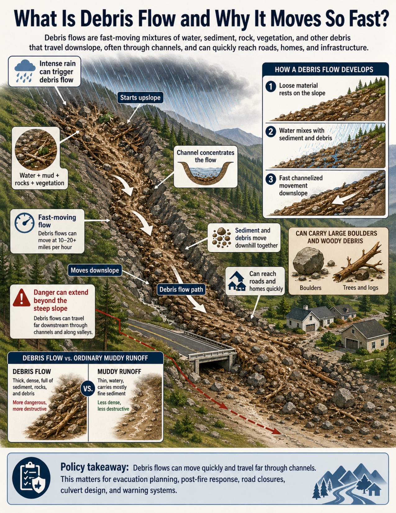
What the visual shows
The visual shows a steep mountain watershed during intense rainfall. Loose sediment, rocks, mud, branches, and vegetation are mobilized upslope as water mixes with the material.
The moving mixture becomes a debris flow. It travels downslope through a channel, carrying sediment and debris together. Large arrows show the debris flow path from the upper slope toward lower areas.
A side panel shows how a debris flow develops in three steps. First, loose material rests on the slope. Second, water mixes with sediment and debris. Third, the mixture becomes a fast channelized flow moving downslope.
The visual also shows that debris flows can carry large boulders and woody debris such as trees and logs. A comparison panel distinguishes debris flow from ordinary muddy runoff. Debris flow is thicker, denser, and more destructive, while muddy runoff is thinner, more watery, and carries mostly fine sediment.
Why this matters for policy
Debris flows are important for policy because they can move quickly and travel beyond the steep slopes where they begin. A flow that starts in an upper watershed can move through a channel and reach roads, bridges, culverts, homes, utility corridors, or evacuation routes downslope.
Channels and gullies can focus debris-flow hazards. This means that planning should consider where flow paths lead, not only where the steepest slopes are located. A house, road, or bridge at the outlet of a steep drainage may be exposed even if it is on gentler land.
Debris flow risk is especially important after wildfire. Burned slopes may have less vegetation, altered soil conditions, and more loose sediment. During intense rainfall, these areas may shed water and debris more easily.
For policy staff, debris-flow planning can affect evacuation routes, warning systems, post-fire response, road closures, culvert and bridge design, road maintenance, watershed recovery, and land-use decisions near drainage paths.
Key terms
Debris flow
A fast-moving mixture of water, sediment, mud, rocks, vegetation, and debris that flows downslope, often through channels.
Channelized flow
Flow that is concentrated in a channel, gully, drainage, or valley. Channelized debris flows can move quickly and travel far from their source area.
Runout
The distance a debris flow travels from where it begins to where it slows, stops, or spreads out.
Sediment
Loose mineral material such as sand, silt, gravel, cobbles, or boulders.
Woody debris
Branches, logs, burned vegetation, tree trunks, or other plant material carried by a flow.
Culvert
A structure that carries water under a road, trail, railway, or embankment. Culverts can become blocked or overwhelmed by debris flows.
Post-fire debris-flow risk
The increased chance of debris flows after wildfire, especially during intense rain, because burned slopes may shed water and sediment more easily.
Drainage path
A route where water naturally collects and moves downslope, such as a channel, gully, swale, or small valley.
Questions policy staff can ask
- Where are the steep drainages, gullies, channels, or small watersheds that could concentrate a debris flow?
- What roads, homes, utilities, bridges, culverts, or evacuation routes are located downslope from those channels?
- Has the area recently burned, and has post-fire debris-flow risk been assessed?
- Are there known debris-flow paths, alluvial fans, or past deposits in the area?
- Could culverts or bridges become blocked by sediment, boulders, logs, or other debris?
- Are road closures or warning thresholds needed during intense rainfall?
- Do emergency plans account for where debris flows may travel, not just where they may start?
- Are public alerts clear about the difference between ordinary muddy runoff and debris flow?
- Are land-use decisions considering flow paths, runout areas, and downstream exposure?
- Is additional geologic, hydrologic, or engineering review needed before development or repair?
Policy takeaway
Debris flows are fast, channelized ground-and-water hazards, which is why land-use planning, warning systems, and emergency response need to account for where flow paths lead, not just where slopes are steep.
Main concept: Debris flows are fast-moving mixtures of water, sediment, rock, mud, vegetation, and debris that can travel quickly through channels.
Core message: The visual explains that debris flows are not ordinary muddy runoff. They are dense, channelized ground-and-water hazards that can move quickly and carry large debris.
Intense rainfall: The visual shows intense rain falling on a steep watershed. Rain can trigger debris flow when water mobilizes loose material on slopes or in channels.
Starts upslope: The debris flow begins upslope where loose sediment, rocks, branches, and other debris are available to be mobilized.
Material mixture: The visual shows water mixing with mud, rocks, sediment, vegetation, and debris. These materials move downhill together as a dense flow.
Channelized movement: A channel or gully concentrates the moving water and debris, helping the flow move quickly downslope.
Fast movement: The visual uses arrows to show rapid downslope movement along the debris flow path.
Downstream exposure: The debris flow travels toward a road, bridge or culvert, and homes downslope. People and infrastructure may be at risk even if they are not located on the steepest slope.
Boulders and woody debris: The visual shows that debris flows can carry large boulders, trees, logs, and other heavy debris.
Debris flow versus muddy runoff: The guide compares debris flow with ordinary muddy runoff. Debris flow is thicker, denser, and more destructive, while ordinary muddy runoff is thinner and carries mostly fine sediment.
Post-fire risk: Debris flow risk can be especially important after wildfire, when burned slopes may shed water, sediment, and debris more easily.
Policy connection: Debris flows matter for evacuation routes, warning systems, post-fire response, road closures, culvert design, bridge design, road planning, and emergency management.
Policy takeaway: Debris flows are fast, channelized ground-and-water hazards, which is why land-use planning, warning systems, and emergency response need to account for where flow paths lead, not just where slopes are steep.