
Why Wildfire Increases Landslide and Debris-Flow Risk
Explains how wildfire can increase landslide and debris-flow risk by removing vegetation, weakening roots, exposing soil, increasing runoff, and mobilizing sediment and debris during storms.
Wildfire can change how a slope responds to rain. After vegetation, roots, ground cover, and soil structure are altered, burned slopes may shed water and sediment much more quickly than they did before the fire.
This matters for land-use, emergency-management, transportation, and water policy because post-fire storms can send runoff, ash, sediment, rocks, and debris into channels that lead toward roads, culverts, bridges, homes, reservoirs, and water-supply infrastructure.
Download or reuse this guide in briefings and meeting materials.
Why Wildfire Increases Landslide and Debris-Flow Risk
Wildfire can change how slopes and small watersheds respond to rain. After a fire, burned slopes may shed water, ash, sediment, rocks, and debris much more quickly than they did before vegetation, roots, ground cover, and soil structure were altered.
The greatest concern often comes during intense storms after wildfire. A burned slope may already be vulnerable, and heavy rain can quickly turn that vulnerability into runoff, erosion, debris flow, or slope failure.
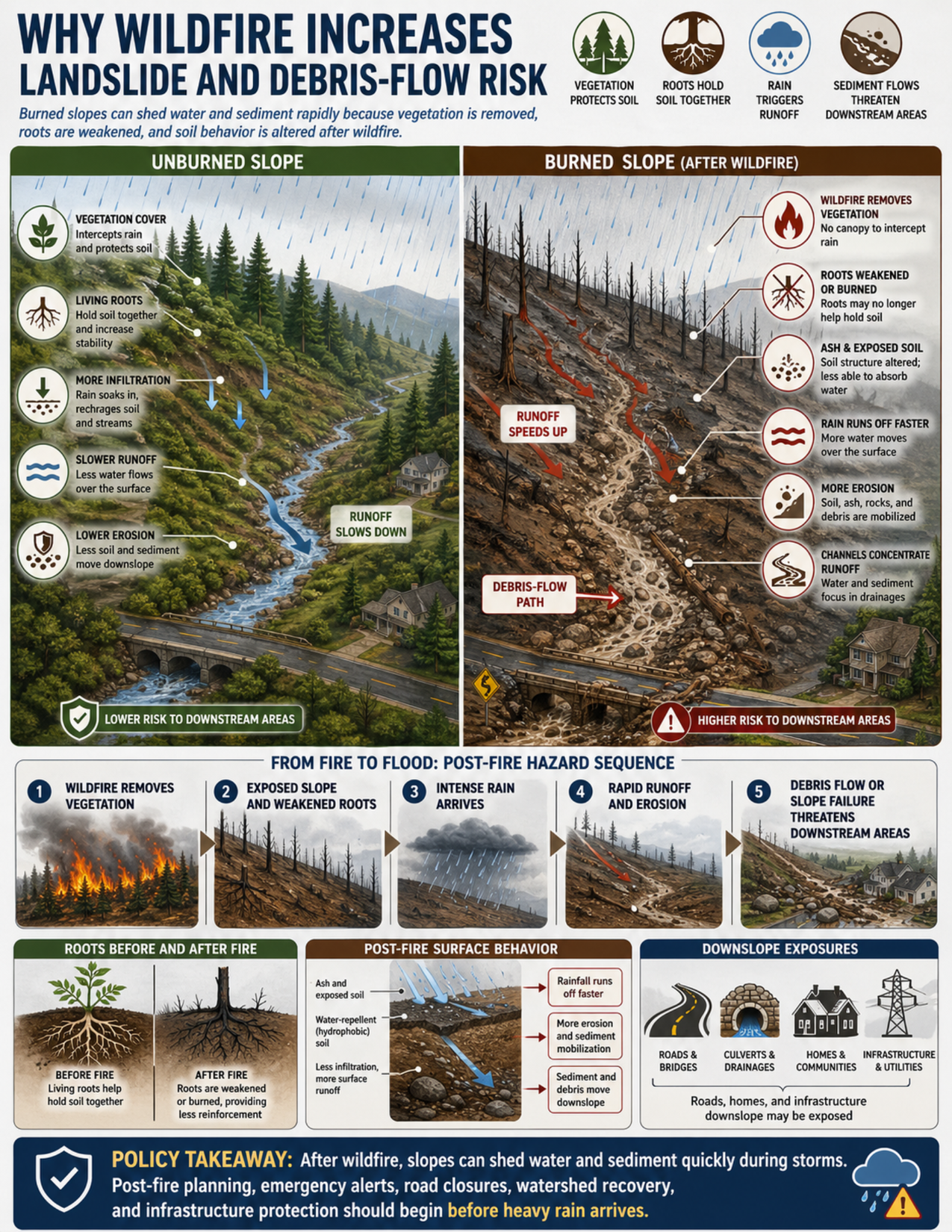
What the visual shows
The visual compares an unburned slope with a burned slope after wildfire.
The unburned slope has vegetation cover, living roots, more infiltration, slower runoff, and lower erosion. Vegetation intercepts rain and helps protect the soil surface. Roots help hold soil together. More rainfall can soak in or move more slowly through the slope and drainage network.
The burned slope shows charred trees, reduced vegetation cover, ash, exposed soil, and weakened or burned roots. Without the same canopy, ground cover, and root reinforcement, rainfall can run off faster over the surface. That faster runoff can pick up soil, ash, rocks, burned vegetation, and other debris.
The visual also shows a post-fire hazard sequence: wildfire removes vegetation, the slope is left exposed with weakened roots, intense rain arrives, runoff and erosion increase, and debris flow or slope failure can threaten downstream areas.
Additional panels show roots before and after fire, post-fire surface behavior, and downslope exposures. Roads, bridges, culverts, drainage paths, homes, communities, utilities, reservoirs, and water-supply infrastructure may all be exposed if runoff and debris are concentrated in channels.
Why this matters for policy
Wildfire can turn a slope-stability problem into a storm-response problem. After fire, the question is not only whether the burned area is unstable, but also where water, sediment, and debris will go during the next intense rainfall.
Post-fire hazards can extend downslope and downstream. A road, culvert, bridge, reservoir, neighborhood, or utility corridor may be exposed even if it is not located on the steepest part of the burned slope. Channels and drainages can concentrate runoff and debris and deliver hazards quickly to lower areas.
This is why post-fire hazard assessment is time-sensitive. Public alerts, evacuation planning, temporary road closures, culvert and drainage inspections, debris removal, watershed recovery, and infrastructure protection may need to begin before the next heavy rain arrives.
Several agencies may have roles. Fire management agencies may define burn severity and affected watersheds. Land management agencies may coordinate stabilization or recovery. Emergency management agencies may issue alerts and plan evacuations. Transportation agencies may inspect roads, bridges, and culverts. Water agencies may need to consider reservoirs, water-supply infrastructure, sediment loads, and water quality.
Key terms
Post-fire debris flow
A fast-moving mixture of water, ash, sediment, rocks, burned vegetation, and debris that can move downslope after wildfire, especially during intense rainfall.
Runoff
Water that flows over the land surface instead of soaking into the ground. Faster runoff can increase erosion and carry sediment and debris into channels.
Infiltration
The movement of water from the surface into soil, sediment, or rock. After wildfire, infiltration may be reduced in some places if surface conditions change.
Water-repellent soil
Soil that resists water infiltration. After some fires, heating and ash can contribute to water-repellent or hydrophobic layers that encourage more surface runoff.
Erosion
The removal and transport of soil, sediment, ash, or rock by water, wind, gravity, or other processes.
Channelized flow
Water, sediment, or debris concentrated in a channel, gully, drainage, or small valley. Channelized flow can move faster and farther than diffuse runoff.
Root reinforcement
The way living roots help bind soil and add strength to a slope. After fire, roots may be damaged, killed, or weakened over time.
Downslope exposure
People, roads, homes, utilities, bridges, culverts, reservoirs, or other assets located where runoff, sediment, or debris may travel.
Questions policy staff can ask
- Which burned slopes or watersheds are most likely to produce rapid runoff, erosion, landslides, or debris flows?
- Has a post-fire hazard assessment been completed before the next heavy rainfall?
- Where do channels, gullies, drainage paths, and culverts carry water and debris from the burned area?
- Are roads, bridges, culverts, homes, utilities, reservoirs, or water-supply infrastructure located downslope or downstream?
- Are emergency alerts, evacuation routes, and road-closure plans ready for intense rainfall?
- Do culverts, bridges, and drainage systems need inspection or clearing before storms?
- Are there areas where burned vegetation, ash, sediment, rocks, or woody debris could block drainage infrastructure?
- Are watershed recovery, erosion-control, or slope-stabilization measures needed?
- Which agencies need to coordinate on burn severity, storm forecasts, public alerts, transportation access, water quality, and infrastructure protection?
- How will risk be communicated to residents who live below burned slopes or near drainage paths?
Policy takeaway
Wildfire can turn a slope-stability issue into a storm-response issue, which is why post-fire landslide and debris-flow planning should happen before the next heavy rainfall.
Main concept: Wildfire can increase landslide and debris-flow risk because burned slopes may shed water and sediment rapidly after vegetation, roots, ground cover, and soil structure are altered.
Core message: The visual explains that wildfire changes the way slopes and small watersheds respond to rainfall, especially during intense storms after a fire.
Unburned slope panel: The left side of the visual shows an unburned slope with vegetation cover, living roots, more infiltration, slower runoff, and lower erosion.
Vegetation cover: Vegetation intercepts rainfall, slows runoff, and helps protect the soil surface.
Living roots: Living roots help hold soil together and increase slope stability.
More infiltration: On the unburned slope, more rainfall can soak into the ground and move more slowly through soil and streams.
Slower runoff: Less water flows rapidly over the surface on the unburned slope.
Lower erosion: Less soil and sediment move downslope when vegetation, roots, and soil structure remain intact.
Burned slope panel: The right side of the visual shows a burned slope after wildfire, with charred trees, reduced vegetation, weakened roots, ash, exposed soil, and faster runoff.
Wildfire removes vegetation: Fire can remove the canopy and ground cover that previously intercepted rainfall and protected soil.
Roots weakened or burned: Roots may no longer help hold soil as effectively after vegetation is burned or killed.
Ash and exposed soil: Ash, bare soil, and altered soil structure can make slopes more vulnerable to erosion.
Rain runs off faster: Rainfall on a burned slope can move more quickly over the surface than rainfall on an unburned, vegetated slope.
More erosion: Faster runoff can pick up ash, sediment, rocks, burned vegetation, and other debris.
Channels concentrate runoff: Drainage paths can focus runoff and debris, creating debris-flow hazards that travel downslope.
Post-fire hazard sequence: The visual shows a sequence from wildfire removing vegetation, to exposed slopes and weakened roots, to intense rain, rapid runoff and erosion, and debris flow or slope failure threatening downstream areas.
Roots before and after fire: The guide compares living roots before fire with weakened or burned roots after fire, showing reduced soil reinforcement.
Post-fire surface behavior: The visual shows ash and exposed soil, possible water-repellent soil behavior, reduced infiltration, more surface runoff, more erosion, and sediment and debris moving downslope.
Downslope exposures: Roads, bridges, culverts, drainages, homes, communities, infrastructure, utilities, reservoirs, and water-supply infrastructure may be exposed where runoff and debris travel downslope.
Policy connection: Post-fire hazard assessment, public alerts, evacuation planning, road closures, culvert inspection, watershed recovery, and infrastructure protection can reduce risk.
Agency roles: Fire management, land management, emergency management, transportation, and water agencies may all have roles in post-fire response.
Policy takeaway: Wildfire can turn a slope-stability issue into a storm-response issue, which is why post-fire landslide and debris-flow planning should happen before the next heavy rainfall.