
Why Karst Terrain Can Produce Sinkholes
Explains how karst terrain forms where soluble rocks such as limestone dissolve underground, creating cavities, conduits, voids, and sinkhole hazards.
Karst terrain develops where soluble rocks such as limestone dissolve in groundwater over time. This process can create underground openings, conduits, and voids that may not be visible from the surface.
This matters for policy because sinkholes and hidden subsurface voids can affect buildings, roads, utilities, stormwater infrastructure, groundwater quality, and water supplies. Surface planning decisions in karst areas should be informed by what may be happening below ground.
Download or reuse this guide in briefings and meeting materials.
Why Karst Terrain Can Produce Sinkholes
Karst terrain develops where rocks such as limestone dissolve in groundwater over time. This can create underground openings, conduits, and voids that may not be visible from the surface.
Sinkholes can form when the ground surface sags or collapses into one of these underground spaces. Some sinkholes develop gradually, while others appear suddenly.
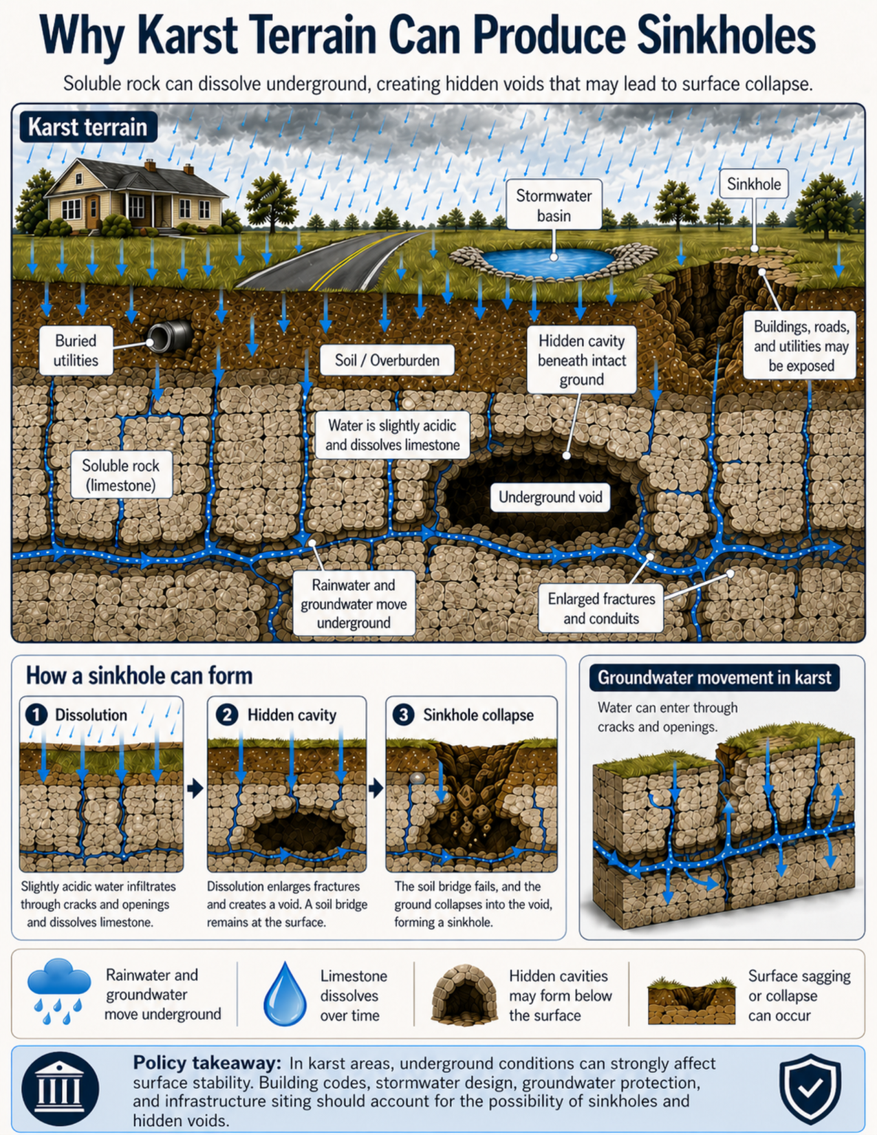
What the visual shows
The visual shows a land-surface and subsurface cross-section of karst terrain. At the surface, there is a house, a road, a stormwater basin, buried utilities, and a visible sinkhole. Below the surface, a soil and overburden layer sits above limestone bedrock.
Blue arrows show rainwater moving downward into the ground and groundwater moving through cracks, fractures, and enlarged conduits in the limestone. The visual identifies limestone as soluble rock, meaning it can dissolve over time when water moves through it.
The cross-section shows a hidden cavity beneath intact ground. This illustrates that the surface may appear stable even when an underground void exists below it. The visual also shows an underground void and enlarged fractures and conduits where water can move through the limestone.
A three-step sequence explains how a sinkhole can form. First, slightly acidic water infiltrates through cracks and dissolves limestone. Second, dissolution enlarges fractures and creates a hidden cavity while a soil bridge remains at the surface. Third, the soil bridge fails and the ground collapses into the void, forming a sinkhole.
A separate panel shows groundwater movement in karst. Water can enter through cracks and openings and may move quickly through connected underground conduits.
Why this matters for policy
Karst terrain matters because surface conditions do not always reveal what is happening below ground. A site may look stable while cavities, enlarged fractures, or voids are present underneath.
Sinkholes and subsurface voids can affect buildings, roads, utilities, stormwater infrastructure, and water supplies. A road, building foundation, buried utility line, or stormwater basin may be vulnerable if it is located above unstable ground.
Stormwater design needs special attention in karst areas. Practices that encourage infiltration may be useful in some settings, but in karst they can also send water rapidly into underground openings, worsen erosion of soluble rock, or create direct pathways to groundwater.
Karst also matters for groundwater protection. Because water can move quickly through fractures and conduits, contaminants from spills, septic systems, stormwater, or surface activities may reach groundwater faster than expected.
Policy responses may include building-code requirements, geotechnical investigation, karst mapping, stormwater review, groundwater protection measures, infrastructure siting standards, and risk communication for property owners and developers.
Key terms
Karst terrain
A landscape formed where soluble rocks such as limestone, dolomite, or gypsum dissolve underground, creating features such as sinkholes, caves, conduits, springs, and disappearing streams.
Soluble rock
Rock that can dissolve in water over time. Limestone is a common soluble rock in karst terrain.
Dissolution
The process of rock dissolving as water moves through cracks, openings, and pore spaces.
Slightly acidic water
Rainwater and groundwater can become slightly acidic by mixing with carbon dioxide in the air or soil. This weak acidity can dissolve limestone over time.
Conduit
An enlarged underground opening or passage that allows water to move through rock.
Underground void
An open space below the ground, such as a cavity, cave, or enlarged fracture.
Soil bridge
A layer of soil or overburden that temporarily spans an underground cavity. If it loses support, the surface may sag or collapse.
Sinkhole
A closed depression or collapse feature at the ground surface that forms when material moves into an underground opening.
Groundwater protection
Actions that help prevent pollution or contamination of groundwater resources.
Site investigation
A technical review of subsurface conditions, often using geologic mapping, borings, geophysics, historical records, or engineering analysis.
Questions policy staff can ask
- Is the site located in mapped or suspected karst terrain?
- Are limestone, dolomite, gypsum, or other soluble rocks present below the site?
- Are sinkholes, depressions, springs, caves, disappearing streams, or subsidence features known nearby?
- Could hidden cavities, enlarged fractures, or underground conduits be present beneath the surface?
- Are buildings, roads, buried utilities, stormwater basins, or other infrastructure planned near known karst features?
- How will stormwater be managed, and could infiltration increase sinkhole risk or rapidly move contaminants underground?
- Are groundwater supplies, wells, springs, or aquifers nearby or downgradient?
- Is a geotechnical or karst-specific site investigation needed before development or infrastructure work?
- Are building codes, setbacks, stormwater requirements, or infrastructure siting standards appropriate for karst conditions?
- How will sinkhole risk and groundwater protection concerns be communicated to property owners, developers, and the public?
Policy takeaway
Karst terrain can create hidden underground instability, so surface planning decisions should be informed by what may be happening below ground.
Main concept: Karst terrain can produce sinkholes where soluble rocks such as limestone dissolve underground and create cavities, conduits, and voids.
Core message: The visual explains that surface conditions do not always reveal what is happening below ground. Hidden cavities may form beneath apparently intact land surfaces.
Karst terrain: The main cross-section shows a landscape in karst terrain, with a house, road, stormwater basin, buried utilities, and a visible sinkhole.
Soluble rock: The visual identifies limestone as soluble rock. Limestone can dissolve slowly when water moves through cracks and openings.
Dissolution: Slightly acidic rainwater and groundwater can dissolve limestone over time, enlarging fractures and creating underground pathways.
Rainwater and groundwater movement: Blue arrows show rainwater infiltrating from the surface and groundwater moving underground through cracks, fractures, conduits, and enlarged openings.
Soil and overburden: The soil and overburden layer sits above the limestone. This material may temporarily bridge a hidden cavity before sagging or collapsing.
Hidden cavity: The visual shows a hidden cavity beneath intact ground, emphasizing that land may appear stable even when a void exists below the surface.
Underground void: Dissolution can create larger underground voids within the limestone.
Sinkhole: A sinkhole forms where the surface sags or collapses into an underground opening.
Groundwater movement: The visual shows that karst can allow water to move quickly underground through connected fractures and conduits.
Exposure: Buildings, roads, buried utilities, stormwater infrastructure, and water supplies may be exposed to sinkhole hazards or groundwater-quality concerns.
Policy connection: Building codes, site investigations, stormwater design, groundwater protection, infrastructure siting, and land-use decisions may need to account for karst hazards.
Policy takeaway: Karst terrain can create hidden underground instability, so surface planning decisions should be informed by what may be happening below ground.