
What Is Subsidence?
Explains that subsidence is the sinking of the land surface and can be caused by groundwater withdrawal, deeper fluid extraction, mining, drainage of organic soils, or compaction of soils and sediments.
Subsidence means the ground surface sinks downward. It may happen gradually and may not be obvious at first, but over time it can damage infrastructure, change drainage patterns, and increase flood risk.
This matters for policy because subsidence connects groundwater management, extraction practices, land-use planning, infrastructure design, and flood-risk reduction. Monitoring ground elevation and groundwater conditions can help identify areas at risk before damage becomes severe.
Download or reuse this guide in briefings and meeting materials.
What Is Subsidence?
Subsidence means the ground surface sinks or lowers over time. It may happen gradually and may not be obvious at first, but its effects can build across years or decades.
Subsidence can be caused by groundwater withdrawal, oil or gas extraction, mining, drainage of organic soils, natural compaction, or compaction of loose sediments. It can damage infrastructure, change drainage patterns, and increase flood risk.
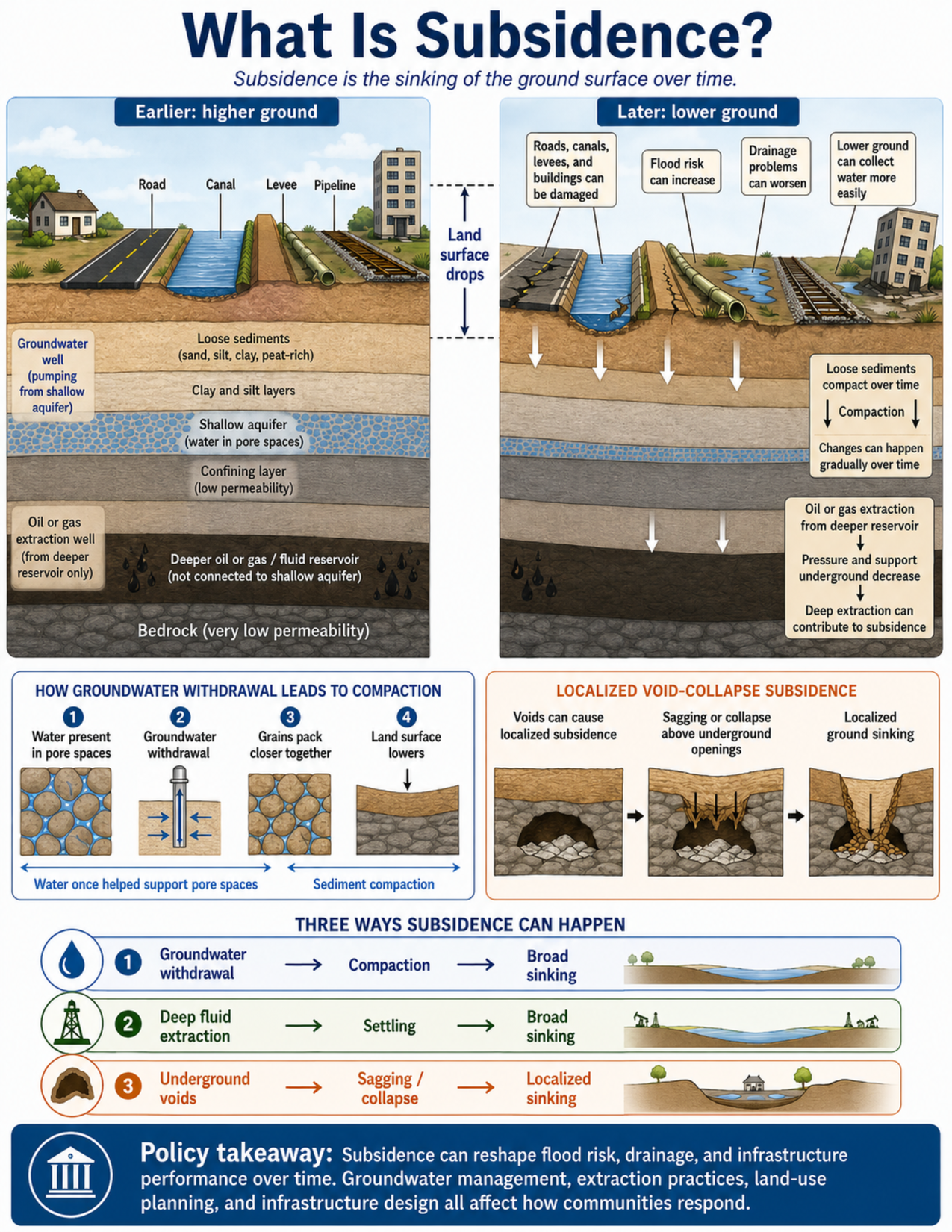
What the visual shows
The visual compares earlier: higher ground with later: lower ground.
The earlier panel shows roads, a canal, a levee, a pipeline, rail lines, buildings, and subsurface layers before major lowering has occurred. The subsurface includes loose sediments, clay and silt layers, a shallow aquifer, a confining layer, a deeper oil or gas reservoir, and bedrock.
The later panel shows the land surface after subsidence. A vertical measurement marker shows that the land surface has dropped. The lower land surface affects roads, canals, levees, pipelines, rail lines, buildings, and drainage.
The visual also shows how groundwater withdrawal can lead to compaction. Water in pore spaces helps support sediment grains. When groundwater is withdrawn, sediments may compact as grains pack closer together. This can lower the land surface.
A separate panel shows localized void-collapse subsidence. Underground voids, such as mined-out areas or solution-created cavities, can cause the ground above them to sag, crack, or collapse.
The summary section shows three ways subsidence can happen: groundwater withdrawal leading to compaction and broad sinking, deep fluid extraction leading to settling and broad sinking, and underground voids leading to sagging or localized sinking.
Why this matters for policy
Subsidence is important because it can affect large areas slowly and quietly. A community may not notice the problem until roads crack, canals lose capacity, pipes break, rail lines distort, foundations settle, or drainage problems become more frequent.
One common cause is groundwater withdrawal from aquifers. When groundwater is pumped faster than the aquifer system can recover, some sediments may compact. In some settings, this compaction can be difficult or impossible to reverse.
Subsidence can also happen when oil, gas, or other fluids are extracted from deeper reservoirs. Mining and underground voids can cause more localized sagging or collapse. Drainage of organic soils can also lower the land surface over time as soils compact and decompose.
Lower ground elevation can increase flood risk. Even a small amount of land lowering can change drainage gradients, make canals or stormwater systems less effective, reduce levee performance, and allow water to pond in places that did not previously flood as often.
Policy responses may include groundwater regulation, extraction monitoring, elevation monitoring, infrastructure design standards, flood-risk planning, land-use decisions, and long-term maintenance planning. These tools can help reduce harm even when subsidence cannot be stopped immediately.
Key terms
Subsidence
The sinking or lowering of the ground surface over time.
Groundwater withdrawal
Pumping groundwater from an aquifer. In some geologic settings, groundwater withdrawal can reduce support in pore spaces and allow sediments to compact.
Aquifer
A body of rock, sand, gravel, or sediment that can store and transmit groundwater.
Pore spaces
Small spaces between sediment grains or within rock. Water in pore spaces can help support some sediment layers.
Compaction
The process of sediment or soil grains packing closer together, reducing volume and causing the land surface above to lower.
Uneven settlement
Lowering that does not happen uniformly across an area. Uneven settlement can crack roads, foundations, canals, pipelines, rail lines, and other infrastructure.
Oil or gas extraction
Removal of oil, gas, or other fluids from deeper underground reservoirs. This can reduce underground pressure and support in some settings.
Underground void
An open space below the ground, such as a mined-out area, solution cavity, or other underground opening. Collapse or sagging above a void can cause localized subsidence.
Organic soils
Soils rich in plant material. When drained, organic soils can compact and decompose, contributing to land-surface lowering.
Ground-elevation monitoring
Tracking changes in land-surface elevation over time using surveys, GPS, satellite data, benchmarks, or other measurement methods.
Questions policy staff can ask
- Is subsidence known or suspected in this area?
- Has ground elevation been monitored over time?
- Are groundwater levels declining, or is groundwater pumping concentrated in the area?
- Are oil, gas, mineral, or other extraction activities occurring nearby or at depth?
- Are there mined-out areas, underground voids, solution cavities, or other subsurface openings?
- Are soils or sediments compressible, such as clay, silt, peat-rich deposits, or organic soils?
- Are roads, canals, levees, buildings, pipelines, rail lines, utilities, or drainage systems showing repeated settlement or cracking?
- Has drainage performance changed over time?
- Could lower ground elevation increase flood risk or reduce levee performance?
- Are groundwater regulation, extraction management, infrastructure redesign, monitoring, or land-use changes needed?
Policy takeaway
Subsidence is a slow-moving land-instability problem with long-term consequences for water management, infrastructure, and flood risk.
Main concept: Subsidence is the sinking or lowering of the ground surface over time.
Core message: The visual explains that subsidence can happen when underground support is reduced or when soils and sediments compact. It can be gradual, widespread, localized, or uneven.
Earlier higher ground: The left panel shows a higher land surface with roads, canals, levees, pipelines, rail lines, buildings, and subsurface layers before major lowering has occurred.
Later lower ground: The right panel shows the land surface after subsidence. A vertical marker shows that the land surface has dropped.
Groundwater withdrawal: One common cause of subsidence is groundwater withdrawal from aquifers. When water is removed from pore spaces, sediments can compact and the land surface can lower.
Sediment compaction: Loose sediments, clay, silt, peat-rich material, and other compressible deposits can compact over time, reducing underground volume and lowering the land surface.
Deeper extraction: Oil, gas, or other fluid extraction from deeper reservoirs can reduce underground pressure and support, allowing overlying layers to settle.
Mining and voids: Mining, underground openings, or solution-created cavities can lead to localized sagging or collapse above underground voids.
Organic soils: Drainage of organic soils can cause compaction and oxidation, contributing to long-term land-surface lowering.
Infrastructure impacts: Subsidence can damage roads, buildings, canals, levees, pipelines, rail lines, utilities, and foundations. It can create cracking, uneven settlement, structural stress, leaks, breaks, and reduced infrastructure performance.
Flood and drainage impacts: Lower ground elevation can increase flood risk, worsen ponding, and change drainage patterns.
Monitoring: Monitoring ground elevation, groundwater levels, extraction rates, and infrastructure condition can help identify areas at risk.
Policy connection: Groundwater regulation, extraction management, infrastructure planning, flood-risk planning, and long-term land-use decisions can reduce harm.
Policy takeaway: Subsidence is a slow-moving land-instability problem with long-term consequences for water management, infrastructure, and flood risk.