
How Riverbank Erosion Causes Land Loss
Explains how rivers naturally erode and reshape their banks, especially during high flows, along outside bends, and as channels migrate across floodplains.
Rivers are dynamic systems that naturally erode banks, deposit sediment, and shift position over time. Riverbank erosion is often strongest during high flows and along outside bends where water pushes against the bank.
This matters for floodplain, transportation, infrastructure, and land-use policy because erosion can cause land loss even where flood depth is not the main concern. Planning near rivers should account for where the channel may move over time, not only where floodwater may rise.
Download or reuse this guide in briefings and meeting materials.
How Riverbank Erosion Causes Land Loss
Rivers are dynamic systems. They naturally erode banks, deposit sediment, and shift across floodplains over time.
Riverbank erosion is often strongest during high flows and along outside bends where moving water pushes against the bank. This means erosion risk should be considered alongside flood inundation risk, especially where roads, bridges, buildings, utilities, farmland, parks, or public access areas are close to the river.
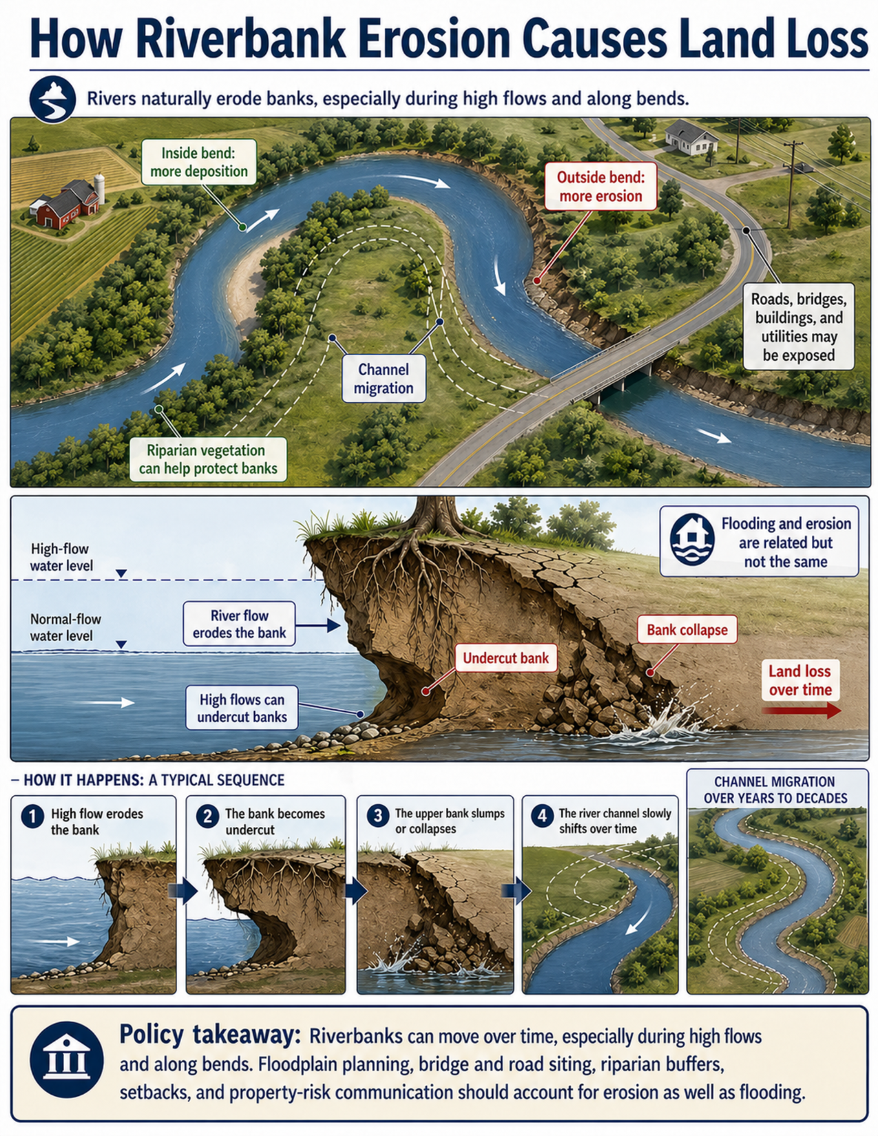
What the visual shows
The visual shows a meandering river from above and a riverbank cross-section from the side.
In the map view, water moves around a bend in the river. The outside bend is labeled as having more erosion because faster, stronger flow is directed against the bank. The inside bend is labeled as having more deposition because slower water allows sediment to build up.
Dashed lines show channel migration, which means the river channel can slowly shift position across the floodplain over years or decades. Nearby roads, bridges, buildings, farm fields, and utilities show that land and infrastructure can be exposed as the channel moves.
The cross-section shows a riverbank during normal flow and high flow. During high flow, water reaches higher on the bank and can remove material from the base. This creates an undercut bank, where the upper bank has less support. The upper bank can then crack, slump, or collapse into the river, causing land loss over time.
The visual also notes that flooding and erosion are related but not the same. Flooding is about water covering land that is normally dry. Erosion is about water removing soil, sediment, or bank material.
Why this matters for policy
Riverbank erosion can cause land loss even where flood depth is not the main concern. A property, road, trail, utility line, bridge approach, or public access area may be threatened because the riverbank is moving, not only because floodwater is rising.
Outside bends are often especially important because water moving around a bend can strike the bank more directly. Over time, this can erode the bank and shift the channel outward. Inside bends may build sediment at the same time, so the river both removes land in one place and deposits material in another.
High flows can speed up erosion by increasing the force of water against the bank. If the base of the bank is undercut, the upper bank may collapse even after the highest water has passed.
Riparian vegetation can help stabilize banks by slowing near-bank flow, reinforcing soil with roots, and reducing surface erosion. However, vegetation may not stop all erosion, especially during large floods, along actively migrating bends, or where banks are already undercut.
Policy tools include setbacks, floodplain management, bridge and road siting, erosion monitoring, riparian buffers, property-risk communication, and infrastructure planning. These tools help communities account for both flood inundation and long-term channel movement.
Key terms
Riverbank erosion
The removal of soil, sediment, or other bank material by moving water.
Meander
A bend or curve in a river channel.
Outside bend
The outer edge of a river bend, where flow is often faster and erosion is commonly stronger.
Inside bend
The inner edge of a river bend, where flow is often slower and sediment is more likely to be deposited.
Deposition
The settling or buildup of sediment carried by water.
Undercut bank
A bank where material has been eroded from the base, leaving the upper bank unsupported or overhanging.
Bank collapse
The slumping, falling, or failure of bank material into the river after the bank is weakened or undercut.
Channel migration
The movement of a river channel across its floodplain over time.
Floodplain
Low-lying land near a river that can store floodwater and may also contain older or future channel positions.
Riparian vegetation
Plants that grow along rivers and streams. Their roots can help stabilize banks, and their stems and leaves can slow water near the bank.
Flood inundation risk
The chance that land will be covered by floodwater.
Erosion risk
The chance that land will be removed or damaged by moving water, even if flood depth is not the main hazard.
Questions policy staff can ask
- Is the site near an outside bend, eroding bank, or active channel migration zone?
- Are roads, bridges, buildings, utilities, farmland, parks, or public access areas close to the riverbank?
- Has the bank edge moved over time in aerial imagery, surveys, or local records?
- Are tree roots exposed, banks undercut, cracks visible near the bank edge, or slump blocks present?
- Are high flows likely to reach and erode the base of the bank?
- Is the concern mainly flood inundation, bank erosion, channel migration, or a combination?
- Could a bridge, culvert, road, or utility line be affected if the channel shifts?
- Are riparian buffers or bank vegetation present, and are they sufficient for the setting?
- Are setbacks, erosion monitoring, or geotechnical or hydraulic review needed?
- How is erosion risk being communicated to property owners, infrastructure managers, and the public?
Policy takeaway
Riverbank erosion is a land-loss hazard, not just a water-level problem. Planning near rivers should account for where the channel may move over time, not only where floodwater may rise.
Main concept: Riverbank erosion causes land loss when moving water removes bank material, undercuts the bank, and allows the upper bank to slump or collapse.
Core message: The visual explains that rivers naturally erode, deposit sediment, and shift over time. Erosion risk should be considered alongside flood inundation risk.
Meandering river: The upper panel shows a meandering river from above. Water moves around bends, with erosion concentrated along the outside bend and deposition concentrated along the inside bend.
Outside bend erosion: Outside bends often have faster, stronger flow against the bank. This can remove bank material and increase land-loss risk.
Inside bend deposition: Inside bends often have slower flow, allowing sediment to build up as point bars or deposits.
Channel migration: Dashed lines show how the river channel can shift across the floodplain over years or decades.
Riparian vegetation: Vegetation along the riverbank can help protect banks by slowing water near the bank and holding soil with roots, although it may not stop all erosion.
Exposure: The visual shows roads, bridges, buildings, utilities, farm fields, and other assets near the riverbank that may be exposed as the channel migrates or the bank erodes.
Riverbank cross-section: The middle panel shows normal-flow and high-flow water levels. High flows reach higher on the bank and can erode the base.
Undercut bank: When high flows remove material from the base of the bank, the upper bank loses support and may overhang the river.
Bank collapse: Once the bank is undercut and weakened, the upper bank can crack, slump, or collapse into the river.
Land loss: Repeated erosion and collapse can move the bank edge landward over time, causing land loss.
Flooding and erosion: The visual notes that flooding and erosion are related but not the same. Flooding is about water covering land; erosion is about moving water removing soil and bank material.
Typical sequence: The sequence shows high flow eroding the bank, the bank becoming undercut, the upper bank slumping or collapsing, and the channel slowly shifting over time.
Policy connection: Setbacks, floodplain management, bridge and road siting, erosion monitoring, riparian buffers, property-risk communication, and infrastructure planning can help reduce exposure to riverbank erosion.
Policy takeaway: Riverbank erosion is a land-loss hazard, not just a water-level problem. Planning near rivers should account for where the channel may move over time, not only where floodwater may rise.