
Why ‘Stable Today’ Does Not Mean ‘Stable Tomorrow’
Explains why slope stability is dynamic and how weathering, erosion, water, vegetation loss, earthquakes, and human activity can change ground conditions over time.
Slope stability is not fixed. A slope that appears stable today may become less stable as weathering, erosion, water, vegetation loss, earthquakes, and human activity alter the ground.
This matters for policy because land-use decisions often rely on current site conditions, while slope risk can change over years or decades. Monitoring, maintenance, updated hazard information, drainage management, and geotechnical review can help communities identify changing conditions before small changes become larger problems.
Download or reuse this guide in briefings and meeting materials.
Why ‘Stable Today’ Does Not Mean ‘Stable Tomorrow’
Slope stability is not fixed. A slope that appears stable today may become less stable as weathering, erosion, water, vegetation loss, earthquakes, and human activity alter the ground.
This means a stable-looking slope should be understood as a snapshot in time, not a permanent condition. Small changes can accumulate over years or decades and increase the chance of cracks, movement, or slope failure.
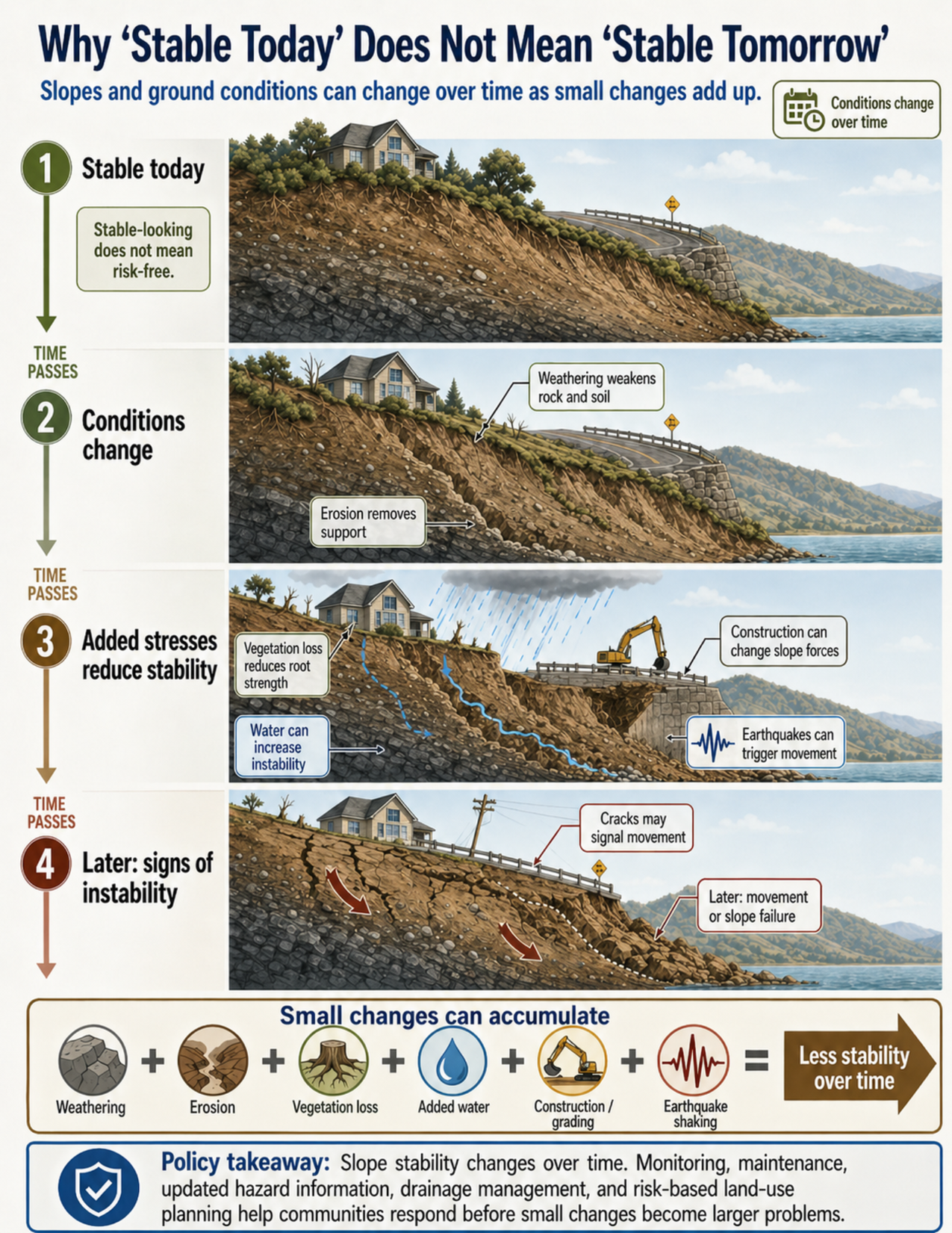
What the visual shows
The visual shows the same developed hillside through time. Each panel shows how conditions can change and how those changes can reduce slope stability.
The first panel shows a slope that appears stable today. A house, vegetation, road, and slope are present, and there are no obvious warning signs. The key message is that a stable-looking slope does not mean the site is risk-free.
The second panel shows conditions changing. Weathering weakens rock and soil, while erosion removes support from the slope. These processes may be gradual, but they can make the slope less able to resist movement.
The third panel shows added stresses that can reduce stability. Vegetation loss reduces root strength. Water moves into the slope. Construction, grading, or excavation changes slope forces. Earthquake shaking is shown as a possible trigger for movement on slopes that are already close to failure.
The fourth panel shows later signs of instability. Cracks appear near the top of the slope, movement arrows show the direction of ground movement, and part of the slope has begun to fail. These signs show that earlier changes have accumulated into a more serious stability problem.
The summary strip at the bottom shows that weathering, erosion, vegetation loss, added water, construction or grading, and earthquake shaking can combine to produce less stability over time.
Why this matters for policy
Slope stability is dynamic. A site that appears safe during one review, inspection, or development decision may become more vulnerable as physical conditions change.
Weathering can gradually weaken rock and soil. Erosion can remove support from the base or sides of a slope. Vegetation loss can reduce the strength provided by roots and can also increase runoff. Changes in water conditions can add weight, reduce friction, or raise pore pressure within the ground.
Human activity can also alter stability. Grading, excavation, road cuts, added fill, irrigation, leaking pipes, septic systems, and changed stormwater flow can all change how water and forces move through a slope. These changes may not cause immediate failure, but they can reduce the margin of safety.
Earthquakes can trigger movement on slopes that were already weakened or close to failure. In this way, a slope may appear stable before an event but fail when a trigger occurs.
Climate-related extremes can also matter. More intense rainfall, drought followed by heavy rain, wildfire followed by storms, coastal erosion, and changing groundwater conditions can all affect how slopes behave over time.
Policy decisions should account for future conditions, not only current appearance. Monitoring, maintenance, drainage management, updated hazard mapping, and geotechnical review can help identify changing conditions before small problems become larger hazards.
Key terms
Slope stability
The ability of a slope to resist movement. Stability depends on slope angle, material strength, water conditions, vegetation, loading, erosion, and triggers such as earthquakes.
Weathering
The gradual breakdown of rock or soil by water, temperature changes, chemical reactions, plant roots, or other processes.
Erosion
The removal of soil, sediment, or rock by water, waves, wind, ice, or gravity. Erosion can remove support from the base or sides of a slope.
Vegetation loss
Removal or death of plants that can reduce root strength and increase runoff. Roots can help bind soil, while vegetation can slow water moving across the surface.
Root strength
The added strength that plant roots can provide by helping hold soil together.
Pore pressure
The pressure of water in the spaces between soil grains or within cracks. Higher pore pressure can reduce the strength of a slope.
Added water
Water from rainfall, irrigation, stormwater, seepage, leaking pipes, or septic systems. Added water can increase weight, reduce friction, and increase pore pressure.
Construction or grading
Human activity that changes the shape, load, drainage, or support of a slope, including excavation, road cuts, added fill, and slope regrading.
Trigger
An event or change that causes movement on a slope that was already vulnerable. Heavy rainfall and earthquake shaking are common triggers.
Geotechnical review
Technical evaluation of soil, rock, groundwater, slope, and foundation conditions to guide planning, design, or risk reduction.
Risk-based land-use planning
Planning that considers the likelihood and consequences of hazards when deciding where and how development should occur.
Questions policy staff can ask
- Has the slope changed since the last review, inspection, or hazard mapping effort?
- Are there signs of weathering, erosion, cracking, slumping, leaning features, or ground movement?
- Is erosion removing support from the base or side of the slope?
- Has vegetation been removed, burned, stressed by drought, or otherwise reduced?
- Have drainage patterns changed because of development, roads, stormwater systems, irrigation, or leaking infrastructure?
- Could added water increase slope weight, reduce friction, or raise pore pressure?
- Has construction, grading, excavation, road cutting, or added fill changed slope forces?
- Could earthquake shaking trigger movement on a slope that is already weakened?
- Are climate-related extremes, such as intense rainfall, drought, wildfire, or coastal erosion, likely to change future slope conditions?
- Are monitoring, maintenance, updated mapping, or geotechnical review needed?
- Do land-use decisions account for how slope conditions may change over time, not only how they appear today?
Policy takeaway
A stable-looking slope is a snapshot in time. Land-use decisions should account for how slopes may change as water, erosion, vegetation, earthquakes, and human activity alter the ground.
Main concept: Slope stability is dynamic. A slope that appears stable today may become less stable as conditions change over time.
Core message: The visual explains that weathering, erosion, vegetation loss, added water, construction, grading, and earthquake shaking can accumulate and reduce slope stability.
Stable today: The first panel shows a developed hillside with a house, road, vegetation, and no obvious signs of instability. The visual emphasizes that stable-looking does not mean risk-free.
Conditions change: The second panel shows weathering weakening rock and soil, and erosion removing support from the slope.
Added stresses: The third panel shows vegetation loss, water moving into the slope, construction or grading, and earthquake shaking. These changes can reduce root strength, increase instability, and change slope forces.
Later instability: The fourth panel shows cracks, movement arrows, and signs of slope failure. These are visual warnings that the slope has become less stable.
Cumulative change: A summary strip shows that weathering, erosion, vegetation loss, added water, construction or grading, and earthquake shaking can combine to produce less stability over time.
Policy connection: Monitoring, maintenance, updated mapping, drainage management, geotechnical review, and risk-based land-use planning can help communities account for future conditions, not only current appearance.
Policy takeaway: A stable-looking slope is a snapshot in time. Land-use decisions should account for how slopes may change as water, erosion, vegetation, earthquakes, and human activity alter the ground.